Rab
Rab Yacht Charter Guide: Sailing Croatia’s Green Island of Sandy Bays and Historic Harbours
In the northern Adriatic, where the sailing routes of the Kvarner region begin to transition toward the warmer island chains of Dalmatia, lies Rab - one of the most distinctive and visually balanced sailing destinations in Croatia. Known for its forested coastline, protected bays, medieval waterfront skyline, and rare sandy beaches, Rab offers a sailing experience that differs noticeably from the more rugged island environments surrounding it.
For sailors approaching through the wider waters of Kvarner Bay, Rab appears greener and softer than many nearby islands. Pine forests extend toward the sea, long peninsulas shape naturally sheltered anchorages, and the coastline alternates between rocky formations and unusually light sandy sections that are uncommon in the Adriatic. This combination creates a sailing atmosphere that feels calmer, more layered, and visually warmer than the exposed limestone landscapes often associated with northern Croatia.
Unlike islands defined primarily by a single marina hub or concentrated harbour infrastructure, Rab unfolds through a network of bays, coastal villages, and protected sailing corridors. Navigation here becomes less about direct passage-making and more about gradual coastal exploration, where short sailing distances reveal constantly changing scenery and anchorage conditions.
The island also occupies a strategically important position within Adriatic yacht charter routes. Located south of Krk and east of Cres, Rab connects northern Adriatic sailing itineraries with routes extending deeper into central Croatian waters. This positioning allows the island to function simultaneously as a destination, a transitional stop, and a sheltered cruising environment within longer island-hopping itineraries.
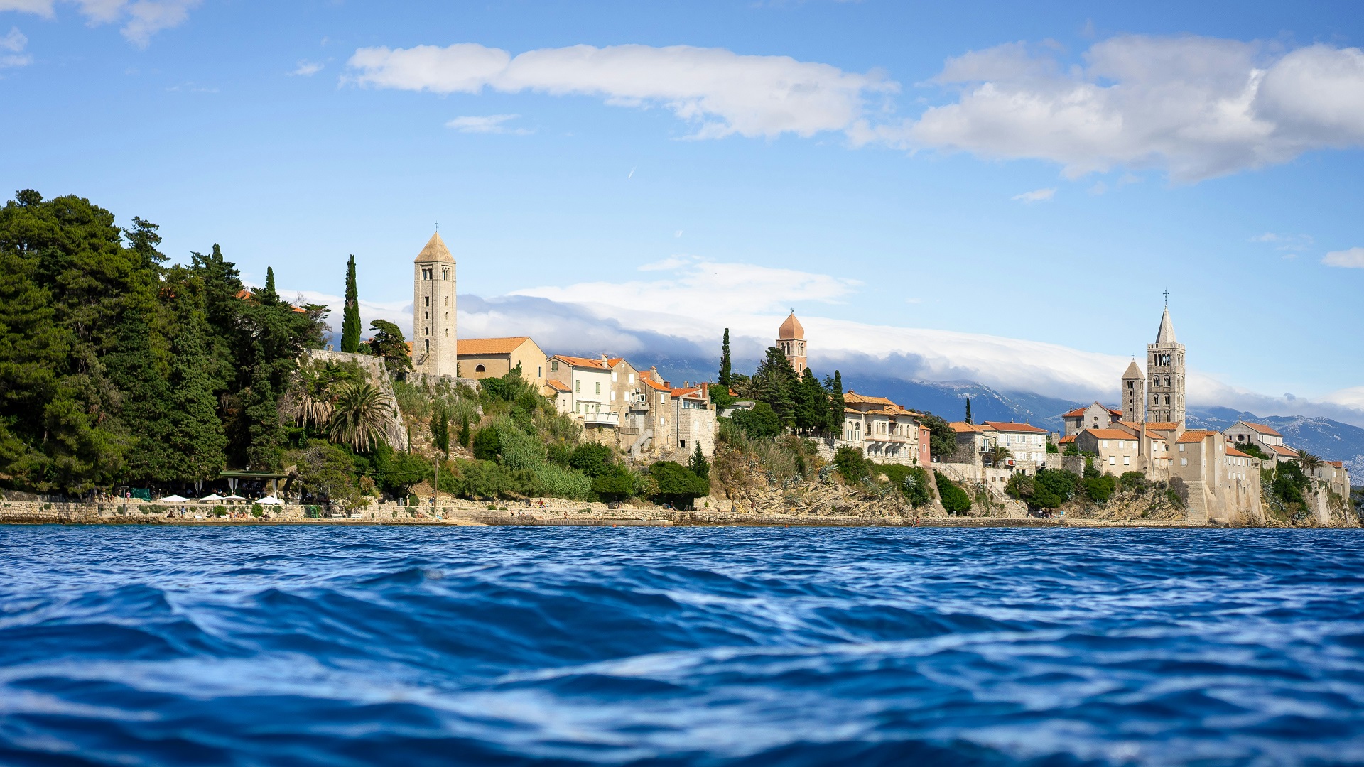
At the heart of the island lies Rab, one of the most recognisable historic harbour towns in the northern Adriatic. Its skyline - defined by stone bell towers rising above the waterfront - creates a distinctive arrival scene for yachts entering the harbour. The old town stretches along a narrow peninsula where marina activity, promenades, historic architecture, and coastal life remain closely connected to the sea itself.
Historically, Rab developed through maritime trade, fishing, and regional navigation routes that linked the island to both mainland Croatia and neighbouring Adriatic islands. Even today, the harbour retains an active maritime identity rather than functioning purely as a seasonal tourism centre. Fishing boats, sailing yachts, ferries, and local coastal traffic continue to shape the rhythm of daily life around the waterfront.
For yacht charter guests, Rab offers one of the most balanced sailing environments in the Adriatic. Protected bays allow for relaxed anchoring and swimming stops, while nearby open-water passages introduce enough navigational variety to keep routes dynamic and engaging. This flexibility makes the island suitable for both slower family cruising itineraries and longer offshore sailing routes through Kvarner.
What ultimately distinguishes Rab is its atmosphere. It combines the natural softness of forested coastlines and sandy coves with the structure of historic Adriatic maritime culture. In a region often defined by exposed rock and dramatic coastal terrain, Rab feels greener, calmer, and more organically connected to the rhythm of the sea.
A Green Island Defined by Forests, Bays, and Maritime Balance
One of the defining characteristics of Rab is the unusual balance it maintains between natural landscape and navigable coastline. Unlike many Adriatic islands where steep rocky terrain and exposed limestone formations dominate the shoreline, Rab presents a softer, greener, and more varied coastal profile shaped by forests, peninsulas, shallow bays, and open maritime corridors.
This diversity gives the island a distinctly layered sailing identity. Rather than offering a single continuous coastline type, Rab shifts gradually between different environments, allowing sailors to experience multiple coastal atmospheres within relatively short sailing distances. The island feels neither completely rugged nor fully sheltered, but balanced between openness and protection.
Large sections of Rab are covered by dense Mediterranean pine forests that extend remarkably close to the shoreline. From the sea, these forests soften the visual outline of the island and create a maritime landscape that feels calmer and more organic than the sharper rock-dominated coastlines common elsewhere in the northern Adriatic. Approaching from open Kvarner waters, the island appears greener, more textured, and visually less exposed than neighbouring islands such as Cres or parts of Krk.
For sailors, this greenery changes not only the appearance of the coastline but also the overall atmosphere of navigation. Pine-covered slopes reaching toward the sea create a sense of shelter and continuity that contrasts with the more elemental open-water character found elsewhere in the region. Even during longer passages, Rab often feels visually protected by its own landscape.
The coastline itself is highly fragmented and structurally diverse. Long peninsulas extend into the sea, dividing the shore into a sequence of bays, coves, and semi-enclosed coastal sections. These formations create natural harbour-like environments where wind and wave exposure can change significantly over relatively short distances.
This geography is particularly important from a sailing perspective because it allows for highly adaptable route planning. Yachts can move quickly between open passages and sheltered anchorages depending on changing weather conditions, sea state, or desired cruising pace. During stronger wind periods, protected bays provide calmer alternatives, while more exposed outer sections continue to offer open-water sailing opportunities for longer passages.
The fragmented nature of the coastline also creates a slower and more exploratory style of navigation. Rather than moving directly between major harbours, sailors often progress gradually along the island, stopping frequently in smaller bays or using peninsulas as natural transition points between sailing environments.
Another defining feature of Rab is the presence of sandy coastal zones, which remain relatively rare within Croatia’s predominantly rocky Adriatic geography. These sandy areas influence both the texture of the coastline and the visual appearance of the sea itself. In shallow bays, the seabed reflects sunlight differently, producing lighter turquoise tones and softer water colour gradients than the deeper blue environments surrounding more rocky islands.
For sailors accustomed to traditional Adriatic rock formations and cliff-lined coves, these sandy sections create a noticeably different coastal experience. Shorelines appear gentler, transitions between land and sea feel less abrupt, and anchorage areas often take on a warmer and more relaxed visual character.
Importantly, Rab is not defined by any single landscape element alone. Its identity emerges through the coexistence of multiple contrasts operating together: dense forests beside exposed stone coastlines, open-sea corridors beside protected bays, historic harbour towns beside undeveloped coastal stretches.
This coexistence gives Rab a uniquely balanced maritime atmosphere within the Adriatic. It is an island where navigation, nature, and settlement remain closely interconnected, allowing sailing routes to move fluidly between calm anchorage environments, historic waterfronts, and open Kvarner passages without losing continuity of experience.
Sailing Approach to Rab: Historic Harbour Arrivals and Open Kvarner Passages
Approaching Rab by yacht typically begins with navigation across the wider waters of Kvarner Bay before gradually transitioning into increasingly sheltered coastal corridors shaped by the island’s peninsulas, bays, and natural harbour geometry. This progression from open water into protected maritime space is one of the defining characteristics of arriving at Rab.
Unlike islands where dramatic cliffs or steep elevations dominate the horizon from great distance, Rab reveals itself more gradually. From offshore, the island appears as a long green landmass with relatively low but clearly structured coastal forms. Forested ridges rise softly above the sea, while elongated peninsulas extend outward into surrounding waters, creating a layered and horizontally balanced silhouette.
This softer visual profile gives the approach a distinctly calmer atmosphere compared to more rugged northern Adriatic islands. Rather than appearing abrupt or imposing, Rab feels accessible and naturally integrated into the surrounding sea space. The island’s greenery further reinforces this impression, softening the coastline visually and creating a stronger sense of shelter even before vessels reach protected waters.
As yachts move closer, the maritime structure of the island becomes progressively more defined. Coastal contours separate into individual bays and harbour zones, while the outline of Rab gradually emerges along its peninsula setting. From the sea, the town’s bell towers form the most recognisable visual markers, rising above stone buildings and waterfront promenades that follow the natural line of the harbour.
This arrival scene is among the most distinctive harbour approaches in northern Croatia. The combination of medieval architecture, marina activity, and naturally enclosed water creates a transition that feels both historic and functional. Unlike purely marina-oriented arrivals where infrastructure dominates the waterfront, Rab retains a clear visual relationship between its historic town core and the harbour itself.
The harbour entrance is generally straightforward during stable summer conditions. Coastal visibility is usually good, navigation markers are clearly positioned, and the surrounding bays help reduce direct sea exposure during the final approach. This creates a gradual and comfortable entry process even during peak sailing season, when maritime traffic across Kvarner increases significantly.
Because the harbour is naturally integrated into the island’s coastal geometry, manoeuvring tends to feel progressive rather than compressed. Sailors are not forced into sudden directional changes or narrow entrance channels, but instead move steadily from open water into calmer harbour conditions.
An important aspect of arriving at Rab is that navigation rarely ends at the first harbour stop. The island’s coastline contains numerous indentations, protected coves, and secondary coastal routes that invite continued exploration beyond the main marina area. Short passages lead toward quieter anchorage zones, swimming bays, and smaller coastal settlements distributed around different sections of the island.
This fragmented coastal structure changes the rhythm of sailing itself. Arrival at Rab often functions not as a final destination, but as a transition into slower island-based cruising where navigation becomes more local, flexible, and exploratory. Sailors frequently continue moving between bays after entering the island system, using Rab less as a single stop and more as a connected network of coastal experiences.
Ultimately, the sailing approach to Rab captures many of the qualities that define the island as a whole: openness balanced by shelter, historic maritime identity integrated with natural geography, and a sailing environment where movement continues long after the first harbour arrival.
Sailing Conditions Around Rab Island
The sailing environment around Rab reflects the wider dynamics of the Kvarner Bay region while remaining noticeably more sheltered and adaptable than some of the more exposed nearby islands. Positioned between open sea corridors and fragmented coastal protection, Rab offers a balanced sailing landscape where conditions can shift meaningfully without becoming excessively demanding for most summer cruising itineraries.
During the main sailing season, the Maestral wind is the dominant weather pattern. This northwesterly thermal breeze typically develops during the afternoon hours and creates reliable conditions for inter-island navigation and relaxed coastal passage-making. Around Rab, the Maestral often remains moderate and well distributed due to the island’s geography. The combination of peninsulas, forested ridges, and fragmented bays helps soften the wind structure compared to more open Kvarner sailing areas.
As a result, sailing conditions frequently feel controlled rather than fully exposed. Yachts can maintain steady movement along outer coastal sections while still remaining relatively close to sheltered water. This is particularly useful during longer summer itineraries, where crews may wish to balance active sailing with comfortable onboard conditions.
Morning conditions around Rab are often calm, especially within the island’s protected harbour zones and enclosed bays. During these early hours, sea surfaces typically become smoother and wind intensity remains low, creating ideal conditions for departures, harbour manoeuvring, anchoring operations, and shorter repositioning passages between nearby anchorages.
These calmer morning periods also contribute to the island’s relaxed cruising rhythm. Rather than requiring tightly timed navigation windows, Rab allows for gradual daily movement where crews can depart later, stop frequently, or adapt routes according to comfort and weather development throughout the day.
The Bura wind remains the most important stronger-weather influence affecting the wider region. Originating from the northeast and accelerated by the mainland mountain system near the Velebit range, Bura conditions can significantly affect open channels and exposed coastal sections around northern Croatia. Around Rab, its impact is generally strongest along outer passages and open-water routes facing the mainland side of Kvarner.
During active Bura periods, sea states in exposed areas can become steeper and more dynamic, particularly where wind funnels through wider maritime corridors. Gusts may arrive suddenly and with considerable strength, requiring more attentive route planning and awareness of exposure levels along different parts of the coastline.
However, one of Rab’s major navigational advantages is the availability of nearby shelter. The island’s fragmented coastline contains numerous bays, peninsulas, and naturally protected inner sections that allow sailors to reposition quickly when conditions become less comfortable offshore. Routes can often be adjusted within relatively short distances, moving from exposed sea corridors into calmer anchorage zones without major itinerary disruption.
This proximity between open and protected environments is what gives Rab its distinctive sailing flexibility. Crews can experience genuine open-water navigation across Kvarner while still retaining access to sheltered bays suitable for anchoring, swimming, or overnight stays.
The island’s geography also supports a wide range of cruising styles. Sailors seeking longer passages and more active sailing conditions can use Rab as part of broader inter-island routes toward Dalmatia or the outer Kvarner islands. At the same time, those preferring slower-paced coastal cruising can remain within the island’s protected bays and shorter sailing corridors, rarely needing to venture far into fully exposed waters.
Ultimately, the sailing conditions around Rab are defined by balance. Exposure and shelter exist in close proximity, allowing itineraries to remain both dynamic and adaptable. This combination makes Rab particularly attractive for mixed-style Adriatic sailing routes, where open-sea navigation, protected anchoring, and relaxed coastal exploration can all exist within the same cruising environment.
Marinas, Anchorages, and Protected Coastal Bays
One of the major strengths of sailing around Rab is the diversity of anchorage environments available within relatively short sailing distances. Unlike islands where navigation revolves around one dominant marina or a limited number of harbour options, Rab offers a more distributed coastal structure where marinas, bays, and natural anchorage zones coexist within a compact and highly navigable island system.
This creates a sailing rhythm based on flexibility rather than fixed routing. Crews can move gradually along the coastline, selecting overnight stops, swimming bays, or sheltered anchorages according to weather conditions, preferred atmosphere, or daily cruising distance without needing to commit to long offshore passages.
The harbour at Rab serves as the island’s primary marina and provisioning centre. Positioned directly beneath the historic old town, the marina environment is closely integrated into the surrounding urban waterfront rather than separated into a purely nautical complex. Yachts berth alongside promenades, stone buildings, cafés, and restaurants that remain visually and functionally connected to the harbour itself.
This integration creates a distinctly Adriatic harbour atmosphere where maritime activity and everyday coastal life overlap naturally. The marina retains a practical and accessible scale, allowing sailors to manage provisioning, shore access, and evening waterfront activities without the intensity or spatial separation associated with larger commercial charter hubs.
From the water, the visual identity of the harbour is defined by the old town skyline, particularly the sequence of historic bell towers rising above the waterfront. This architectural backdrop gives the marina a strong sense of place and continuity with the island’s maritime history, reinforcing the feeling that sailing here remains connected to a long-established harbour culture rather than purely seasonal tourism infrastructure.
Beyond the main harbour, Rab opens into a highly varied coastal anchorage system. Numerous bays are distributed around the island’s fragmented shoreline, many of them naturally protected by elongated peninsulas and forested coastal formations. These areas are particularly well suited for daytime anchoring, swimming stops, and overnight stays during stable summer weather.
The geometry of these bays plays an important navigational role. Because many are partially enclosed, they reduce direct exposure to prevailing northwesterly Maestral winds and soften sea movement within inner sections of the anchorage. This creates calmer water conditions that are especially attractive for relaxed cruising itineraries and multi-day stays around the island.
The western and southern coastlines of Rab are particularly valued among sailors due to their combination of shelter, water clarity, and natural scenery. Here, pine forests often extend close to the sea, creating a green coastal backdrop that contrasts with the open blue of surrounding Kvarner waters. In calm conditions, these bays develop exceptionally stable surfaces and high underwater visibility, making them ideal for swimming directly from anchor.
Unlike destinations centred around a single marina stay, Rab encourages movement between bays throughout the day. Many yachts operate within a slower cruising rhythm, relocating over short distances between anchorages according to sunlight, wind direction, or desired level of seclusion. This flexibility is one of the defining features of sailing around the island.
The island’s anchorage network also supports a wide range of sailing styles. Some crews use Rab as a relaxed base for coastal exploration and swimming-focused itineraries, while others integrate the island into longer open-water passages through the Kvarner region. Because protected bays remain close to more exposed sailing corridors, transitions between active navigation and calm anchoring can happen quickly and naturally.
Ultimately, the marina and anchorage structure around Rab reflects the island’s broader sailing identity: balanced, adaptable, and deeply connected to the natural form of the coastline. Rather than concentrating maritime life into one dominant harbour system, Rab distributes the sailing experience across a sequence of protected bays, historic waterfronts, and navigable coastal spaces that encourage continuous exploration.
Swimming Around Rab: Sandy Bays and Clear Adriatic Water
Swimming around Rab differs noticeably from many other northern Adriatic islands due to the island’s unusual coastal composition and the presence of sandy seabeds in several sheltered areas. In a region where rocky shorelines and deep-water coastal drops are more common, Rab introduces a softer and more varied interaction between land and sea.
This distinction becomes immediately visible from the water. In many of the island’s protected bays, shallow sandy seabeds reflect sunlight upward through the surface, creating lighter turquoise tones that contrast strongly with the darker blue environments typical of deeper rocky coastlines elsewhere in the Kvarner region. During calm weather and strong summer sunlight, the water becomes exceptionally clear and reflective, often giving sheltered bays a luminous appearance.
The gradual transition from shoreline to deeper water also changes the overall swimming experience. Instead of abrupt underwater depth changes common around steep Adriatic islands, certain areas around Rab allow for gentler entry into the sea and wider shallow-water zones around anchored yachts. This softer underwater topography contributes to the island’s reputation as one of the more comfortable and accessible swimming environments in northern Croatia.
For sailors arriving from islands such as Cres or Krk, this change in coastal texture often feels significant. Rab introduces a different visual rhythm to Adriatic cruising - one where water colour, seabed composition, and shoreline geometry create a calmer and warmer atmosphere around anchorages.
At the same time, the island still retains many classic Adriatic swimming characteristics. Along more open coastal sections, rocky formations descend directly into clear blue water, while pine-covered shorelines create shaded edges along the coast. In these areas, the swimming environment becomes deeper, more open, and visually more dramatic, particularly where forested peninsulas meet exposed sea corridors.
This contrast between sandy sheltered bays and rocky open-water coastlines is one of the island’s defining maritime qualities. Sailors can transition easily between calm, shallow swimming environments and more exposed natural coastal sections within the same itinerary, often over very short sailing distances.
The western and southern parts of Rab are especially popular for swimming-focused anchorages due to their protected orientation and calmer sea conditions during typical summer weather patterns. Here, yachts frequently anchor for extended midday stops, allowing crews to spend long periods in the water while remaining surrounded by forested coastal scenery and quiet maritime conditions.
Because many bays remain partially enclosed by peninsulas and natural coastal formations, water movement often stays limited during stable conditions. This creates smooth sea surfaces that are particularly suitable for relaxed swimming directly from the boat. In the early morning and late afternoon, when wind influence decreases further, the sea can become almost mirror-like within protected anchorages.
Importantly, swimming around Rab is rarely separated from the sailing experience itself. Rather than functioning as an organised beach destination centred around developed waterfront infrastructure, the island supports a more fluid style of maritime movement where swimming becomes integrated directly into daily navigation routines.
Crews often move gradually between bays throughout the day, stopping spontaneously in calm sections of coastline for swimming, lunch breaks, or short anchoring pauses. The fragmented geography of the island encourages this slower and more flexible cruising rhythm, where the coastline itself becomes a sequence of natural swimming environments rather than a collection of formal destinations.
The clarity of the sea further enhances this experience. Away from harbour zones and increased boat traffic, underwater visibility is generally excellent, especially during prolonged periods of stable summer weather. The combination of sandy seabeds, rocky underwater formations, and minimal industrial coastal development contributes to consistently clean and visually transparent water conditions.
Ultimately, swimming around Rab reflects the island’s broader sailing identity: balanced, adaptable, and closely connected to the natural form of the coastline. It is an environment where sheltered turquoise bays, pine-covered shores, and open Adriatic water coexist within a compact sailing area, allowing swimming and navigation to blend naturally into a single continuous coastal experience.
Evening Atmosphere in Rab Town
Evenings in Rab unfold in a way that reflects the island’s broader maritime character - calm, layered, and closely tied to the rhythm of the sea. As daylight fades and temperatures soften after the intensity of the sailing day, the waterfront naturally becomes the focal point of movement and social life.
The promenade along the harbour basin gradually fills with quiet activity. Restaurants, cafés, and marina terraces open directly toward the water, creating an uninterrupted visual connection between dining spaces and anchored yachts. From a sailing perspective, this proximity is one of the defining qualities of Rab’s evening atmosphere: there is no separation between town life and harbour life, only a continuous transition between the two.
As night approaches, the historic skyline of Rab becomes the dominant visual element. The island’s well-known bell towers rise above stone buildings and reflect across the calm inner harbour waters, producing one of the most recognisable evening scenes in the northern Adriatic sailing network. The water surface often remains still in sheltered conditions, allowing lights from the old town and moored vessels to blend into a soft, shifting reflection across the bay.
Unlike larger urban coastal destinations where nightlife can become dense and fast-paced, Rab maintains a more balanced evening rhythm even during peak summer months. The harbour remains active, with yachts arriving, departing, and repositioning within the marina, but the overall movement is distributed and measured rather than concentrated or overwhelming. This creates an atmosphere that feels open and navigable even at its busiest moments.
For crews arriving after a full day of sailing across Kvarner Bay, this slower pace is particularly noticeable. The transition from open-water navigation to a calm, illuminated harbour setting reinforces a sense of arrival that is both functional and atmospheric. Even simple activities - walking the promenade, dining by the water, or observing harbour movement - take on a relaxed, unhurried quality.
The surrounding natural environment plays an equally important role in shaping the evening mood. Forested areas and elevated green zones around the town help contain artificial light and reduce the sense of urban expansion. This natural framing gives the harbour a more intimate scale, even when multiple yachts are present.
In many sections of the island, particularly those slightly removed from the central waterfront, nighttime conditions become noticeably quieter. The soundscape shifts toward natural coastal elements - light wind movement, gentle water motion against hulls, and distant harbour activity - rather than continuous urban noise. This reinforces the impression that Rab remains closely connected to its island geography rather than functioning as a fully urbanised coastal centre.
Even close to the marina, the sense of separation from mainland intensity remains strong. The island’s position within the wider Kvarner archipelago, combined with its forested coastline and contained harbour structure, creates an environment where evening life feels self-contained and maritime in character.
Ultimately, evenings in Rab represent a balance between activity and calmness. The town remains alive with movement and light, yet never loses its sense of scale or island identity. For sailors, it offers a natural conclusion to the day’s navigation - one where the transition from sea to shore feels seamless, and where the harbour itself becomes part of the evening experience rather than merely a stopping point.
Rab’s Position Within Adriatic Yacht Charter Routes
Rab occupies a particularly strategic and adaptable position within northern Adriatic yacht charter itineraries. Unlike islands that function primarily as end destinations or isolated cruising zones, Rab sits at a natural transition point between different sailing systems - linking the structured waters of the Kvarner region with the more open and dispersed island geography further south.
To the north, sailing routes naturally reconnect toward Krk, Cres, and the broader network of Kvarner Bay. This northern corridor is defined by relatively shorter inter-island distances, varied coastal shelter, and frequent access to both mainland and island harbours. Within this system, Rab functions as a southern extension of the Kvarner cruising zone, marking the point where island landscapes begin to open further and navigation gradually shifts toward more expansive sea conditions.
To the south, routes continue into the island systems of northern Dalmatia, where sailing distances become longer and the geography becomes increasingly fragmented. Islands are more widely spaced, passages extend further across open water, and itineraries often transition into multi-day cruising segments. In this context, Rab represents the final major northern reference point before entering a more dispersed Adriatic sailing structure.
This dual orientation - northward toward structured Kvarner cruising and southward toward open Dalmatian routes - gives Rab a uniquely flexible navigational role. It is not confined to a single sailing identity but instead operates as a bridge between two distinct maritime regions.
Because of this positioning, Rab functions effectively as both a standalone cruising destination and a transitional stop within longer Adriatic itineraries. Sailors can choose to base part of their route around the island itself, exploring its bays, anchorages, and historic harbour towns, or use it as a stepping stone within broader north–south sailing movements.
The island’s internal diversity reinforces this flexibility. Protected bays along its coastline provide calm anchoring environments suitable for relaxed cruising days, while more exposed outer sections connect directly into open Kvarner waters for longer passages. This combination allows itineraries to shift naturally between sheltered island navigation and more active offshore sailing without requiring significant changes in route structure.
Structured harbour facilities, particularly around Rab, further enhance its role within yacht charter planning. Provisioning, marina access, and sheltered overnight berthing are all readily available, making the island a practical stop for both short and extended sailing routes.
At the same time, Rab’s open-sea accessibility ensures that it remains integrated into wider Adriatic navigation patterns rather than functioning as a closed cruising area. Sailors can continue directly toward southern islands or return north into Kvarner without navigating restrictive or overly sheltered passages.
Ultimately, the position of Rab within Adriatic yacht charter routes is defined by adaptability. It supports multiple sailing directions, accommodates varying itinerary lengths, and offers both sheltered and open-water conditions within a single island system. This makes it one of the most structurally useful and geographically versatile stops in the northern Adriatic sailing network.
Final Thoughts: Why Rab Belongs on an Adriatic Sailing Route
Rab stands out within the Adriatic not through extremes, but through balance. It does not rely on dramatic cliffs, remote isolation, or high-density marina infrastructure to define its sailing identity. Instead, its strength lies in how comfortably multiple coastal characteristics coexist within a single, coherent island system.
On one side, Rab offers protected sailing conditions shaped by its peninsulas, forested bays, and naturally enclosed anchorages. On the other, it remains fully open to broader navigation routes across Kvarner Bay, allowing sailors to move seamlessly between sheltered cruising and more exposed passages depending on wind and itinerary direction.
This dual nature gives the island a distinctive maritime rhythm. Historic harbour towns such as Rab bring structure, provisioning options, and cultural atmosphere directly to the waterfront, while the surrounding coastline remains largely natural, fragmented, and ideal for quiet anchoring or swimming stops. Within short sailing distances, crews can shift between urban maritime environments and undeveloped coastal scenery without leaving the island system.
The presence of forested landscapes and rare sandy bays further strengthens Rab’s uniqueness within the Adriatic. These softer coastal elements introduce a different visual and sailing experience compared to more typical rocky islands in the region. Water colours shift, shoreline transitions feel gentler, and anchorages often take on a calmer, more sheltered character - especially during stable summer conditions.
For sailors, this combination translates into high practical versatility. Rab supports relaxed coastal cruising, flexible anchorage planning, structured marina stays, and longer transitional passages within a single connected route. It can function as a quiet cruising base, a provisioning stop, or a strategic waypoint between northern and southern Adriatic sailing regions.
Unlike destinations defined primarily by intensity or remoteness, Rab offers a more measured sailing experience. It remains accessible without feeling crowded, historic without becoming overwhelming, and naturally varied without losing coherence. The island’s geography encourages movement, but never forces it - allowing itineraries to evolve organically according to weather, crew preference, and sailing style.
Within the wider Kvarner region, Rab represents one of the clearest expressions of balanced island cruising. It sits at the intersection of shelter and exposure, tradition and functionality, nature and navigation. This equilibrium is what makes it particularly well suited to multi-day Adriatic yacht charter itineraries, where variety, flexibility, and comfortable progression between sailing environments are essential.
Ultimately, Rab belongs on an Adriatic sailing route because it embodies the core strengths of the region itself: diversity of coastline, accessibility of navigation, and a maritime culture that remains closely tied to the natural rhythm of the sea.
Rab Yacht Charter Guide - Sailing Croatia’s Green Island of Bays and Heritage Harbours
Discover Rab through a yacht charter in the Adriatic, where forested coastlines, sandy bays, and historic harbour towns meet calm anchorages and open Kvarner sailing routes. A versatile island for relaxed cruising, swimming stops, and seamless northern Adriatic itineraries.
Send request