Mali Lošinj
Mali Lošinj Sailing Guide: A Green Adriatic Harbour Between Open Sea Routes and Protected Island Waters
In the northern Adriatic, where the maritime geography of the Kvarner region gradually opens toward the wider island systems of Croatia, lies Mali Lošinj - one of the most distinctive and strategically positioned sailing destinations in the northern Adriatic. Located on the island of Lošinj, the town combines a naturally protected harbour, strong maritime heritage, and direct access to both sheltered inter-island routes and more exposed offshore passages leading deeper into the Adriatic Sea.
Unlike many coastal sailing centres in Istria, where navigation often follows relatively predictable and linear coastal patterns, Mali Lošinj introduces sailors to a more fragmented and dynamic maritime environment. Here, the coastline breaks into a network of islands, channels, passages, and open sea corridors where weather, visibility, and sea state begin to play a more active role in route planning. The Adriatic no longer feels contained by a nearby mainland coast. Instead, it widens visually and spatially, creating a sailing atmosphere defined equally by protection and exposure.
For sailors arriving from the calmer coastal routes further north, this transition is immediately noticeable. The surrounding archipelago continuously reshapes the relationship between shelter and openness. Narrow channels can suddenly lead into broad sea horizons, while protected bays remain only short distances from fully exposed passages. This constant variation is one of the defining characteristics of sailing around Lošinj and contributes significantly to the region’s appeal among experienced cruisers and long-distance sailors alike.
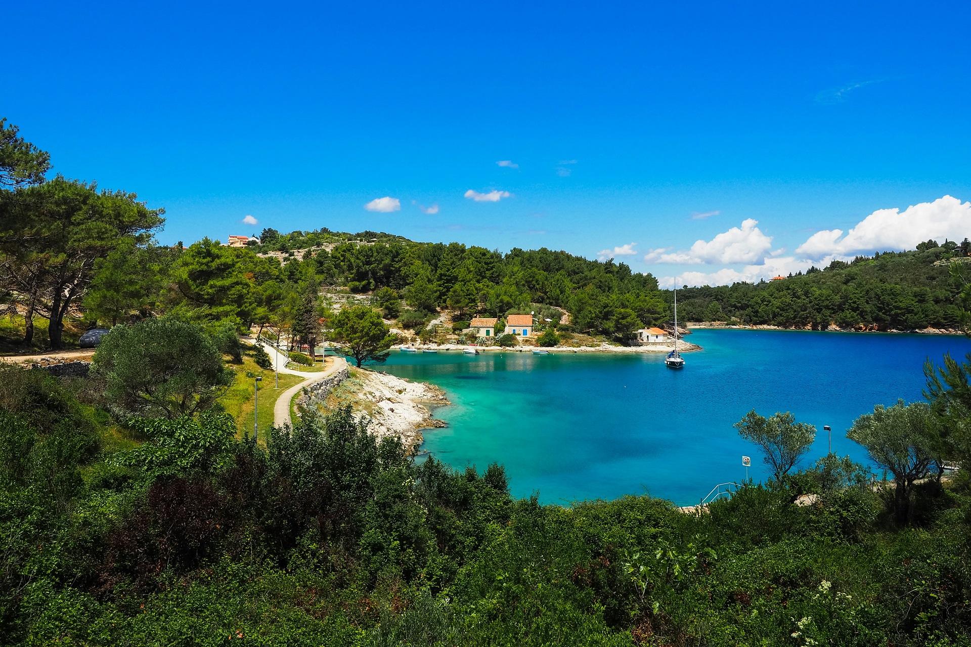
The town itself is built around a deep and elongated harbour that cuts inland from the open sea, forming one of the most recognisable natural harbour environments in the Kvarner region. Approaching by yacht is a highly visual experience. Vessels enter through a defined maritime corridor where the surrounding landscape gradually narrows around the bay. Forested hillsides descend toward the water, waterfront houses begin to cluster along the harbour edge, and marina activity increases progressively as the vessel moves deeper inland.
This approach creates a particularly strong sense of arrival. Unlike open marina complexes positioned directly on exposed coastline, the harbour of Mali Lošinj feels enclosed and naturally protected, shaped directly by the geography of the island itself. The transition from open water into calm harbour conditions is gradual and spatially dramatic, making it one of the most memorable harbour entries in the northern Adriatic.
The visual identity of the harbour is further shaped by the island’s dense Mediterranean vegetation. Pine forests cover large sections of the surrounding slopes, creating a green maritime landscape that distinguishes Lošinj from more barren or rocky Adriatic islands further south. From the water, this greenery softens the coastline and contributes to the calm, protected atmosphere that defines much of the sailing experience here.
Historically, Mali Lošinj developed into one of the Adriatic’s important maritime and shipbuilding centres. During the nineteenth century, Lošinj sailors and shipowners became closely connected to international maritime trade routes, and the town’s prosperity was built directly on navigation and seafaring. This historical relationship with the sea continues to shape the town today.
Unlike destinations whose nautical identity exists primarily through seasonal tourism, the maritime culture of Mali Lošinj is deeply structural and long-standing. The harbour is not simply a modern recreational marina zone added onto a coastal settlement - it is the historical core around which the town evolved. Even today, this continuity remains visible through active waterfront movement, mixed maritime traffic, fishing activity, local vessels, and the broader nautical infrastructure supporting both residents and visiting yachts.
This creates a maritime atmosphere that feels active and authentic rather than purely seasonal. Sailing life in Mali Lošinj continues beyond the charter calendar, reinforcing the sense that the town belongs to the sea in a more permanent and historical way.
For sailing itineraries, Mali Lošinj functions simultaneously as a destination, a shelter point, and a strategic connector within the Adriatic sailing network. From here, routes extend southward toward islands such as Ilovik, Silba, and the outer Dalmatian archipelago, while northern passages reconnect toward the Kvarner islands and mainland coastal regions.
This positioning gives Mali Lošinj unusual flexibility within sailing itineraries. It can operate as a provisioning base, a transitional harbour between northern and southern Adriatic routes, or a longer stop within island-focused cruising plans. At the same time, its naturally protected harbour environment offers security and operational stability in a region where sea conditions can become considerably more dynamic than along the western coast of Istria.
The surrounding waters of the Kvarnerić region are particularly important in shaping this role. Unlike enclosed coastal sailing corridors, these waters introduce broader sea exposure, more active wind interaction, and longer visual distances between islands. For many sailors, this marks the point where Adriatic cruising begins to feel more oceanic in scale and rhythm, even while remaining within protected island geography.
Ultimately, what distinguishes Mali Lošinj within the Adriatic is its balance between natural protection and open maritime access. It is a harbour deeply connected to the sea historically, geographically, and operationally - a place where island sailing becomes broader, more layered, and more closely shaped by the interaction between wind, water, and navigation itself.
A Harbour Defined by Geography and Maritime History
The defining feature of Mali Lošinj is unquestionably its harbour - one of the most naturally distinctive harbour environments in the northern Adriatic. Unlike open marina complexes positioned along relatively flat or externally exposed coastlines, the harbour here forms a deep and elongated inlet carved directly into the island landscape of Lošinj. This geographical structure shapes not only the physical appearance of the town, but also the entire rhythm of maritime life within it.
The urban layout of Mali Lošinj follows the contours of the inlet itself. Rather than spreading outward across a broad coastline, the town wraps closely around the harbour in a compact but extended formation, creating a continuous interaction between waterfront activity and the surrounding island terrain. Buildings, promenades, marina facilities, and harbour infrastructure all develop in direct relation to the water, reinforcing the sense that the town evolved from the harbour rather than merely beside it.
From offshore, the entrance to the harbour appears relatively narrow and visually restrained compared to the wider basin concealed further inland. This creates a gradual and highly atmospheric arrival sequence for approaching vessels. As yachts move inward from the open Adriatic, the surrounding coastline slowly begins to close around the navigation channel. Forested slopes descend toward the water, waterfront structures become denser, and the scale of the maritime environment gradually shifts from open sea to protected harbour interior.
This transition is one of the defining sensory experiences of arriving in Mali Lošinj. The movement from exposed offshore waters into the calm interior basin creates a strong perception of shelter and enclosure, particularly after longer passages across the Kvarnerić region. Unlike harbours that reveal themselves immediately from offshore, Mali Lošinj unfolds progressively, reinforcing the feeling of entering a protected maritime refuge hidden within the island landscape.
The natural geometry of the harbour also provides important navigational advantages. Its elongated and enclosed structure reduces direct exposure to swell and helps moderate sea conditions within the inner basin. Even when offshore waters become more active, the harbour itself often retains relatively calm conditions, making it a highly valued shelter point for both local and visiting vessels.
Surrounding this maritime environment are the heavily vegetated slopes that define much of Lošinj itself. Pine forests dominate the hillsides and extend close to the shoreline, creating one of the greenest large-island landscapes in the Adriatic. From the sea, this vegetation softens the visual profile of the island and contributes to the calmer, more protected atmosphere that distinguishes Lošinj from the harsher limestone landscapes found elsewhere along the Croatian coast.
This greenery is not only aesthetic but also spatially influential. The forests frame the harbour visually, creating a layered maritime landscape where sea, settlement, and vegetation remain closely intertwined. In certain light conditions, particularly during early morning or evening arrivals, the combination of dark green slopes and reflective harbour water gives the entire inlet a distinctly enclosed and sheltered character.
Historically, the harbour of Mali Lošinj became one of the most important maritime centres in the Adriatic during the nineteenth century. Shipbuilding, long-distance navigation, and overseas trade transformed the town into a significant seafaring community whose influence extended well beyond the Kvarner region. At its peak, Lošinj captains and shipowners maintained active connections with international maritime routes across the Mediterranean and beyond.
This maritime heritage remains deeply embedded within the structure of the town today. Old captain’s houses, waterfront buildings, and harbour layouts still reflect the period when navigation and commerce formed the foundation of local life. Unlike destinations whose nautical identity emerged primarily through modern tourism development, Mali Lošinj possesses a maritime culture shaped through centuries of continuous seafaring activity.
Because of this continuity, the harbour atmosphere feels fundamentally different from purely recreational marina environments. Even during the height of the charter season, Mali Lošinj retains the character of an active maritime settlement rather than a seasonal tourism hub designed exclusively for leisure sailing.
Fishing vessels, local boats, private yachts, and visiting charter crews all coexist within the same harbour environment, reinforcing the sense that the town continues to function as a working coastal community. Maritime movement here feels integrated into everyday life rather than staged around tourism infrastructure alone.
This balance between natural geography and maritime history is ultimately what defines the harbour of Mali Lošinj. It is not simply a safe anchorage or a marina destination, but a place where landscape, navigation, and seafaring tradition remain inseparable. Within the northern Adriatic, few harbours combine such strong geographical identity with such deep historical continuity, making Mali Lošinj one of the most authentic maritime centres in Croatian sailing waters.
Sailing Conditions Around Mali Lošinj
The sailing environment around Mali Lošinj is notably more dynamic and varied than many northern Adriatic coastal regions due to its geographical position between sheltered island channels and the broader open waters of the Kvarnerić area. Here, sailors encounter a maritime landscape where conditions can shift significantly over relatively short distances, creating a sailing experience that feels more layered and responsive to geography than along simpler mainland coastal routes.
Unlike the western coast of Istria, where navigation often follows a relatively linear shoreline with moderate exposure, the waters surrounding Lošinj are fragmented by islands, narrow passages, open sea corridors, and changing coastal orientations. This complexity directly influences wind behaviour, sea state, and route planning, giving the area a distinctly more maritime character.
During the main summer season, the Maestral remains the dominant wind pattern. Typically arriving from the northwest during the afternoon hours, it creates reliable and enjoyable sailing conditions for inter-island navigation throughout the Kvarner region. Around Lošinj, however, the Maestral is shaped continuously by the surrounding island geography. As wind moves through channels, across open passages, and around headlands, its strength and direction can vary locally in ways that are less predictable than along open mainland coasts.
This interaction between land and sea gives sailing around Mali Lošinj a more active and engaging quality. Sailors frequently experience transitions between calmer protected waters and more energetic open stretches within the same passage. In narrow channels, wind acceleration can create stronger localized airflow, while nearby sheltered bays may remain relatively calm at the same moment.
Morning conditions are often particularly stable, especially within protected harbour environments and enclosed anchorages. Inside the deep inlet of Mali Lošinj itself, the sea commonly remains smooth during early hours, with minimal wave activity and light wind influence. These calmer periods are ideal for harbour departures, sail preparation, anchoring manoeuvres, and shorter repositioning passages between nearby islands.
Visibility during mornings is frequently excellent, allowing clear views across the surrounding archipelago and open sea horizons. Combined with relatively low traffic levels early in the day, this creates especially pleasant conditions for relaxed coastal navigation and exploratory sailing around the island network.
As the afternoon develops and the Maestral strengthens, sailing conditions become more energetic while generally remaining manageable during stable summer weather. The open-water passages between islands begin to show greater wind texture and wave development, particularly in areas directly exposed to northwesterly airflow. These conditions are often highly appreciated by sailing crews seeking more active navigation without entering fully demanding offshore environments.
The Bura wind introduces a different dynamic altogether. Around Mali Lošinj and the wider Kvarnerić region, the Bura can have a considerably stronger impact than along the more sheltered western coast of Istria. When active, this cold northeasterly wind accelerates through gaps between islands and across open sea corridors, sometimes producing sharp gusts and rapidly changing sea conditions.
In exposed passages, the Bura can create steeper wave patterns and more technically demanding navigation, particularly for vessels crossing broader open-water sections. Wind acceleration around island headlands and through narrower channels can further intensify local conditions, requiring careful route planning and close attention to forecasts.
At the same time, one of the major advantages of the Lošinj sailing region is the availability of nearby shelter. The surrounding island network contains numerous protected bays, alternative passages, and harbour options that allow crews to adapt routes relatively quickly when weather conditions change. This flexibility is one of the reasons the region remains attractive even in periods of more variable weather.
Because exposure and protection exist in such close proximity, sailors can often choose between different types of navigation within the same itinerary. Short protected passages can be combined with longer open-water crossings, allowing routes to be tailored according to experience level, weather stability, and sailing objectives.
This balance is ultimately what defines the sailing character of Mali Lošinj. It appeals equally to crews seeking calm island cruising among sheltered bays and to sailors looking for more expansive Adriatic navigation across open sea corridors. Few northern Adriatic destinations offer such a wide range of sailing environments concentrated within a relatively compact geographical area.
Within the broader Croatian sailing landscape, Mali Lošinj occupies an important transitional zone - where coastal cruising begins to evolve into more open and strategically varied island navigation, and where the Adriatic starts to reveal a more expansive maritime identity.
Island Connections and Sailing Routes
One of the greatest advantages of sailing from Mali Lošinj is its exceptional connectivity to multiple island groups, navigation corridors, and route directions across the Adriatic. Positioned between the northern Kvarner region and the outer island systems leading toward Dalmatia, Mali Lošinj occupies a strategic maritime crossroads where several distinct sailing environments converge.
Unlike coastal destinations whose routes are largely limited to linear north–south navigation along a mainland shoreline, Lošinj opens into a far more flexible island network. From here, sailors can move between sheltered internal channels, open sea crossings, remote island anchorages, and longer offshore passages without requiring major route deviations. This flexibility makes Mali Lošinj particularly valuable for itineraries that combine both relaxed island cruising and more ambitious Adriatic navigation.
To the south, sailing routes continue toward islands such as Ilovik and Silba before extending deeper into the outer Dalmatian sailing network. These southern passages gradually introduce a noticeably different maritime atmosphere. The islands become more dispersed, open-water crossings lengthen, and the visual scale of the Adriatic begins to expand.
As vessels move further south from Mali Lošinj, the coastline feels progressively less enclosed by mainland influence. Navigation becomes increasingly defined by island orientation, sea exposure, and longer-distance route planning rather than simple coastal progression. For many sailors, this transition marks the beginning of a more classic Adriatic island-cruising environment, where open horizons and isolated anchorages become central parts of the experience.
The southern routes also tend to feel warmer and more Mediterranean in atmosphere during the peak summer season. Vegetation changes subtly, sea colours intensify in protected bays, and the spacing between islands creates a stronger sense of maritime openness compared to the more compact northern Adriatic geography.
To the north, sailing routes reconnect toward the wider Kvarner region and the northern Adriatic mainland. Passages can lead back toward islands such as Cres and onward toward mainland coastal centres and the sailing waters of Istria. These northern connections are especially useful for itineraries combining island navigation with mainland provisioning points and more sheltered coastal cruising.
Because of this positioning, Mali Lošinj functions less as an isolated destination and more as a transitional maritime hub connecting different Adriatic sailing regions. It forms a natural bridge between the relatively contained northern coastal waters and the broader, more island-dominated navigation patterns further south.
This role becomes particularly important for longer sailing itineraries. Crews moving between Kvarner and Dalmatia often use Mali Lošinj as a strategic stop for route adjustments, provisioning, weather assessment, or transitional overnight stays before crossing into more open island corridors.
At the same time, the waters immediately surrounding Lošinj provide highly flexible short-range cruising opportunities suitable even for shorter itineraries. Nearby islands, channels, and protected bays allow sailors to design compact sailing days without sacrificing navigational variety.
Within relatively short distances, routes can alternate between exposed offshore passages and calm internal anchorages. A crew may spend part of the day sailing through open Kvarnerić waters with steady afternoon wind, then anchor only hours later inside a sheltered pine-fringed bay protected by surrounding islands. This constant interplay between movement and shelter is one of the defining characteristics of sailing around Mali Lošinj.
The geography of the region also allows itineraries to remain highly adaptable. Because multiple route options often exist between destinations, sailors can adjust plans according to weather conditions, wind direction, sea state, or personal preference without significantly disrupting overall navigation goals. This flexibility is particularly valuable during periods of changing Bura conditions or stronger open-sea exposure.
In practical terms, Mali Lošinj supports several different sailing styles simultaneously. It works equally well for relaxed coastal island cruising, exploratory inter-island navigation, transitional long-distance routing, and more ambitious offshore-oriented passages through the northern Adriatic.
Few sailing bases in Croatia offer such a balanced combination of accessibility, route diversity, and geographical connectivity. Within the wider Adriatic sailing network, Mali Lošinj stands out as a point where island navigation becomes multidirectional, adaptable, and deeply shaped by the surrounding maritime landscape.
Anchorages and Protected Bays
The waters surrounding Lošinj contain a wide variety of protected bays, natural anchorages, and sheltered coastal inlets that make the region especially attractive for summer sailing itineraries. Unlike sailing areas dominated primarily by marina infrastructure and harbour-based stops, the Lošinj archipelago offers a navigation environment where time at anchor becomes an essential part of the overall sailing experience.
One of the defining characteristics of these anchorages is their strong connection to the natural landscape. Many bays are framed by dense pine forests that descend almost directly to the shoreline, while rocky coastal sections create a distinctly Adriatic setting shaped more by geography than development. Compared to larger marina-based destinations elsewhere along the Croatian coast, these anchorages often feel quieter, less structured, and more integrated into the surrounding environment.
This natural atmosphere is particularly noticeable during early mornings and evenings, when wind activity decreases and the surrounding bays become exceptionally calm. In these periods, the combination of still water, forested slopes, and minimal coastal noise creates a highly protected and isolated feeling even within relatively accessible sailing routes.
Water clarity throughout the area is typically excellent away from major harbour zones. In stable weather conditions, when sediment movement remains low and wave activity is limited, visibility beneath the surface can become remarkably clear. This is especially true within smaller sheltered bays where boat traffic is reduced and the seabed remains relatively undisturbed.
The seabed itself commonly consists of mixed rock, sand, and seagrass areas, contributing both to good water transparency and generally reliable anchoring conditions in appropriate depths. Because many bays remain naturally formed rather than heavily engineered, anchoring often feels more exploratory and spatially connected to the surrounding coastline.
Among the most popular nearby overnight stops is Ilovik, located just south of Lošinj. Ilovik is particularly valued among sailors for its protected anchorage conditions, calm maritime atmosphere, and slower island rhythm. The island’s harbour and surrounding bays provide excellent shelter during stable summer weather, making it one of the preferred overnight stops within the wider Kvarnerić sailing region.
The atmosphere around Ilovik differs noticeably from larger charter-oriented destinations. Maritime activity remains present, but the scale is smaller and more dispersed. Instead of dense marina infrastructure or busy waterfront traffic, the island offers a more relaxed anchorage environment where sailing routines follow the natural rhythm of weather, daylight, and sea conditions.
One of the major practical advantages of sailing around Lošinj is the relatively short distance between many anchorages and protected bays. This proximity allows for highly adaptable daily planning. Sailors are rarely forced into long fixed passages between overnight stops, which means itineraries can remain flexible and responsive to changing conditions.
A crew may choose to spend only a few hours under sail before stopping in a nearby bay for swimming, lunch, or an overnight stay. Alternatively, longer passages across more open Kvarnerić waters can be balanced with protected anchorages later in the day. This flexibility supports a sailing style that feels less rigid and more responsive to weather, sea state, and onboard preference.
The geography of the region plays a central role in creating this adaptability. Around Lošinj, sheltered inlets and exposed sea corridors often exist within close proximity to one another. Sailors can move quickly between protected and open-water environments without major route deviations, allowing a single itinerary to include multiple navigation styles.
In practical terms, this means that crews can actively choose the type of sailing experience they want on a given day. Protected bays and calm internal channels are available during periods of stronger wind or when a slower pace is preferred, while nearby open passages offer more dynamic sailing conditions for crews seeking longer reaches and steadier wind exposure.
This balance between shelter and openness is one of the defining strengths of the Lošinj sailing region. The anchorages are not isolated from the broader maritime environment, but directly connected to it through a network of channels, crossings, and island passages that continuously reshape the sailing experience.
Ultimately, the protected bays around Mali Lošinj represent far more than simple stopping points. They form an integral part of the region’s maritime identity - places where navigation slows, the surrounding landscape becomes dominant, and the Adriatic feels simultaneously expansive and sheltered within the same sailing day.
Swimming and the Green Island Atmosphere
Swimming around Mali Lošinj is deeply shaped by the island’s natural environment and by the distinctive landscape of Lošinj itself. Unlike more urbanised or heavily developed coastal regions of the Adriatic, large sections of the surrounding shoreline here remain densely forested, allowing the sea and vegetation to merge into a single continuous landscape. This creates one of the most recognisable “green island” atmospheres anywhere in Croatian sailing waters.
The visual identity of the coastline is defined by pine forests that extend unusually close to the waterline. In many bays, trees descend directly toward rocky shore sections, creating shaded coastal edges and a stronger sense of enclosure than on more exposed limestone islands further south. From the water, this vegetation softens the island profile and gives the surrounding bays a calm, protected appearance that feels markedly different from the brighter and more barren landscapes common elsewhere in the Adriatic.
This greenery plays an important role in shaping the swimming experience itself. Instead of swimming in open resort-style environments dominated by beach infrastructure or urban waterfronts, sailors around Lošinj often find themselves surrounded by forested slopes, natural coastline, and quiet anchorages where the sounds of wind and water dominate over human activity.
The sea throughout the region is generally very clear, particularly outside the main harbour channel of Mali Lošinj and within outer bays protected from stronger maritime traffic. In stable weather conditions, visibility beneath the surface becomes exceptionally high, especially during calmer mornings when wave movement and sediment disturbance remain minimal.
Rocky coastline sections alternate naturally with smoother access points and quieter coves suitable for temporary anchoring and swimming stops. Some bays offer gradual entry into deeper water, while others feature steeper rocky edges where the sea quickly turns dark blue only a short distance from shore. This variation creates a constantly changing coastal texture that makes short swimming stops feel visually distinct from one another even within relatively compact sailing distances.
The outer bays around Lošinj are especially valued for their combination of calm water and open-sea visibility. In many locations, swimmers can remain within sheltered conditions while still looking outward toward wider Adriatic horizons and distant islands. This balance between protection and openness contributes significantly to the feeling of immersion in the maritime landscape.
One of the defining aspects of swimming in this region is the relationship between forest and sea. Pine trees often provide shade directly above swimming areas, and the scent of Mediterranean vegetation remains present even while anchored offshore. This interaction between land and water creates a distinctly sensory sailing environment where the island itself becomes inseparable from the experience of being at sea.
Compared to flatter coastal regions further north, the atmosphere around Mali Lošinj feels more spatially layered and environmentally immersive. The combination of forested slopes, open sea corridors, and protected bays produces a landscape where swimming is not simply recreational but closely tied to the surrounding geography and rhythm of navigation.
Importantly, swimming here is rarely separated from sailing activity itself. Rather than relying primarily on organised beach zones or developed coastal facilities, crews typically integrate swimming directly into the structure of the sailing day. Protected bays become natural pause points between passages, where vessels anchor temporarily for lunch, rest, or time in the water before continuing onward through the island network.
This creates a more fluid relationship between movement and stopping. Swimming is not treated as a separate destination-based activity, but as a natural extension of island cruising. A short passage through open water may end in a quiet pine-fringed cove, where the transition from sailing to swimming happens almost immediately and without formal infrastructure.
During calm summer afternoons, many anchorages around Lošinj become almost mirror-like in appearance, with reflections of surrounding forests visible on the water surface. In these moments, the “green island” identity of Lošinj becomes especially apparent, reinforcing the sense that this part of the Adriatic is defined as much by vegetation and atmosphere as by navigation itself.
Ultimately, swimming around Mali Lošinj is shaped by the same qualities that define the island as a sailing destination overall: natural shelter, environmental richness, and a close integration between sea, landscape, and movement through the Adriatic.
Evening Atmosphere in Mali Lošinj
Evenings in Mali Lošinj are shaped by a unique combination of active maritime life and the calmer rhythm of an island environment. Unlike destinations where nightlife dominates the waterfront after sunset, Mali Lošinj retains a strong connection to its harbour identity even during the busiest part of the summer season. The atmosphere remains social and animated, but always closely tied to the movement of the sea and the structure of the harbour itself.
As daylight begins to fade, the waterfront gradually transforms into one of the town’s main social spaces. Restaurants, cafés, marina promenades, and harbour-side terraces extend along the inner basin, creating a continuous line of activity that follows the shape of the inlet. Rather than concentrating around a single central square or entertainment zone, evening movement spreads naturally around the harbour edge, reinforcing the idea that maritime life remains the centre of the town’s identity.
Because the harbour cuts deeply into the island landscape of Lošinj, the entire evening setting feels enclosed and naturally protected. The surrounding slopes narrow around the water, reducing exposure to open sea conditions and creating a calm inner maritime environment even when offshore passages remain more active. This geographical enclosure gives the harbour a particularly intimate atmosphere after sunset.
Reflections play a major role in shaping the visual character of the evening. Harbour lights, waterfront buildings, marina infrastructure, and anchored vessels reflect across the relatively still inner waters, creating shifting surfaces of colour and movement throughout the basin. During calmer nights, the water inside the harbour can become almost mirror-like, amplifying the visual depth of the waterfront and reinforcing the sense of shelter within the inlet.
Yachts, local boats, and passing maritime traffic continue moving through the harbour well into the evening hours. Ferries, smaller vessels, and returning sailing crews maintain a steady rhythm of arrival and departure that keeps the harbour visually active without becoming overwhelming. This continued maritime movement is one of the defining features of Mali Lošinj after dark.
Unlike purely recreational marina destinations where harbour activity slows dramatically once boats are moored, Mali Lošinj preserves the atmosphere of a functioning maritime settlement. The harbour remains operational and connected to daily island life, reinforcing the town’s long-standing seafaring identity even during the modern charter season.
At the same time, the surrounding forests and hillsides help preserve a quieter and more protected atmosphere than in many larger mainland coastal centres. Beyond the immediate waterfront, the island landscape quickly absorbs sound and movement, preventing the harbour zone from feeling excessively urban or heavily commercialised. Even during peak summer months, there is a noticeable sense of spatial calmness surrounding the active waterfront core.
This balance between activity and tranquillity is one of the defining characteristics of evenings in Lošinj. The town feels alive and maritime without becoming chaotic, social without losing its island identity. Sailors can move easily between busy promenade areas and quieter harbour edges where the sounds of water, rigging, and distant boat engines once again become dominant.
For crews arriving after a day of sailing through the Kvarnerić region, this atmosphere often creates a strong sense of relief and arrival. After navigating open passages, exposed channels, or changing wind conditions offshore, entering the calm inner basin of Mali Lošinj in the evening carries a distinctly protective and restorative feeling.
The town’s elongated harbour layout also contributes to the experience. Walking along the waterfront reveals constantly changing perspectives of the basin, marina, surrounding hillsides, and anchored vessels. The interaction between lights, reflections, and harbour geometry gives the evening environment a layered and continuously shifting visual quality.
Dining and evening social life remain closely integrated with the maritime setting. Waterfront restaurants and cafés maintain direct visual contact with the harbour, allowing sailors to remain connected to their vessels and the surrounding sea even while ashore. This continuous relationship between land-based activity and harbour movement reinforces the feeling that the town and the sea operate as a single connected environment.
Ultimately, evenings in Mali Lošinj are defined by balance: between harbour activity and island calmness, between maritime movement and protected stillness, and between the social energy of a sailing destination and the quieter atmosphere created by the surrounding green island landscape.
Final Thoughts: Why Mali Lošinj Belongs on an Adriatic Sailing Route
Mali Lošinj occupies a uniquely important position within the Adriatic sailing landscape. Few destinations in the northern Adriatic combine such a strong balance of protected harbour infrastructure, island atmosphere, maritime history, and direct access to both sheltered cruising waters and more open offshore navigation routes.
What makes Mali Lošinj particularly distinctive is the way these elements remain closely interconnected rather than existing separately. The harbour is shaped directly by the geography of Lošinj itself, the sailing conditions are continuously influenced by the surrounding island network, and the town’s maritime culture still reflects centuries of active seafaring tradition. As a result, sailing here feels deeply integrated into the landscape rather than imposed upon it through modern nautical development alone.
For sailors, the value of Mali Lošinj lies above all in its versatility. It can serve simultaneously as a secure harbour during changing weather conditions, a practical provisioning and logistical base, a transition point between northern and southern Adriatic sailing routes, and a destination fully capable of supporting longer stays on its own.
This flexibility is especially important within the wider Kvarner region, where navigation conditions can vary significantly depending on wind direction, sea exposure, and chosen route. Mali Lošinj provides both security and strategic positioning within this environment, allowing crews to adapt itineraries without losing access to protected harbour conditions or nearby sheltered anchorages.
At the same time, the town is far more than a functional stop within a larger route network. The atmosphere of the harbour, the surrounding pine-covered landscape, and the immediate proximity of open sea passages give the destination a strong sense of maritime identity that extends beyond simple logistics or overnight mooring.
Unlike purely scenic island stops that function mainly as short anchorage destinations, Mali Lošinj supports a complete maritime rhythm. Harbour life remains active throughout the day and evening, local vessels continue sharing the water with visiting yachts, and the connection between coastal life and navigation remains continuously visible.
Likewise, unlike heavily urbanised marina centres where sailing infrastructure can dominate the shoreline, Mali Lošinj preserves a much stronger relationship between harbour activity and natural surroundings. Forested slopes still frame the inlet, open sea horizons remain visible beyond the harbour entrance, and the scale of the town continues to feel connected to the island landscape rather than detached from it.
This combination creates one of the most balanced sailing environments in the northern Adriatic - an environment where practical navigation, natural scenery, and authentic maritime culture coexist without overwhelming one another.
Perhaps most importantly, Mali Lošinj demonstrates clearly how island geography shapes the experience of sailing itself. The surrounding waters are defined by protected channels, exposed sea corridors, changing wind acceleration zones, and constantly shifting relationships between openness and shelter. Every movement through the region is influenced by the structure of the islands and by the interaction between land, wind, and sea.
The forested coastline of Lošinj contributes equally to this identity. Unlike more barren Adriatic islands further south, Lošinj’s greenery softens the maritime landscape and creates a calmer visual atmosphere both underway and at anchor. Combined with the clarity of the surrounding sea and the strong presence of open water just beyond the harbour entrance, the result is a sailing environment that feels simultaneously protected and expansive.
For many sailors, this balance becomes the defining memory of Mali Lošinj itself. It is a place where the Adriatic begins to feel broader and more maritime in scale, yet still retains the shelter, intimacy, and navigational flexibility that make island cruising so rewarding.
Within the northern Adriatic, Mali Lošinj stands as one of the clearest examples of a destination where sailing is shaped not only by marinas or routes, but by geography itself - through wind, water, islands, and the enduring relationship between the sea and coastal life.
Mali Lošinj Sailing Guide
Discover Mali Lošinj, one of the northern Adriatic’s most distinctive sailing destinations, where protected island harbours, forested coastlines, open Kvarner waters, and centuries of maritime tradition create a uniquely balanced Adriatic sailing experience.
Send request