Krk
Krk Sailing Overview: The Largest Adriatic Island in the Northern Kvarner Region
In the northern Adriatic, where the Kvarner region begins to widen into a complex mosaic of islands, channels, and coastal mainland, lies Krk - the largest island in the Adriatic and one of the most strategically important sailing areas in Croatia. Its sheer scale alone sets it apart from surrounding islands, but its true significance comes from how it connects different maritime zones into a single, navigable system rather than existing as an isolated island destination.
Unlike more remote islands such as Susak or Ilovik, Krk is not defined by isolation or separation from the mainland. Instead, it is defined by integration. A bridge connects it directly to the mainland near Kraljevica, making it one of the few Adriatic islands where road access, maritime traffic, and sailing itineraries converge in a single geographical space. For sailors, this creates a rare hybrid environment: an island that still functions as an island in navigational terms, but is simultaneously embedded within mainland infrastructure and accessibility.
This dual identity shapes the entire sailing experience around Krk. On one hand, the island offers full access to classic Adriatic cruising conditions - sheltered bays, exposed coastal stretches, marina towns, and island-to-island passages. On the other hand, it also benefits from mainland proximity, which influences logistics, provisioning, emergency access, and overall route flexibility. Few destinations in the Adriatic combine these two dimensions so seamlessly within a single sailing area.
Krk is also geographically central within the wider Kvarner sailing system. It sits at a natural crossroads between multiple maritime directions, forming a key structural element in northern Adriatic navigation planning. To the north and northwest, sailing routes lead toward the Istrian coastline and the Gulf of Trieste corridor. To the south, passages extend toward Rab and further into the central Adriatic island chain. To the east, the waters open toward the Velebit channel and more exposed Kvarner sea conditions, while western routes connect back into more sheltered island passages.
This positioning gives Krk a role that goes beyond that of a typical island destination. It functions as a navigational anchor point - an island around which routes are structured rather than simply passed through. For sailors planning multi-day itineraries, Krk often becomes a reference node: a place where decisions are made about direction, weather adaptation, and route continuity across the broader Kvarner region.
The scale of Krk reinforces this importance. As the largest Adriatic island, it contains multiple coastal identities within a single landmass, from sheltered bays and marina towns to more exposed eastern shores facing open Kvarner waters. This internal diversity means that Krk does not present a single sailing environment, but rather a collection of micro-regions that respond differently to wind, sea state, and navigation direction.
As a result, sailing around Krk is rarely uniform. Conditions can shift significantly depending on whether a vessel is positioned on the sheltered western side or the more exposed eastern coastline. This internal variation mirrors the island’s broader role in the Adriatic system: not a static destination, but a dynamic maritime space where multiple sailing environments coexist in close proximity.
Ultimately, Krk occupies a unique position in the northern Adriatic because it connects rather than separates. It links mainland Croatia with the island world, bridges sheltered cruising waters with more open Kvarner conditions, and serves as both a destination and a transition point within larger sailing routes.
For sailors navigating the northern Adriatic, Krk is therefore more than just another stop on the map. It is a structural part of the sailing geography itself - an island that helps define how movement, navigation, and route planning unfold across one of the most varied maritime regions in the Mediterranean.
A Diverse Island Shaped by Coastlines and Contrasts
One of the defining characteristics of Krk is its remarkable coastal diversity. Unlike smaller Adriatic islands that tend to present a relatively uniform shoreline identity - either predominantly rocky, forested, or consistently sheltered - Krk functions more like a compact representation of multiple sailing environments within a single landmass. For sailors, this means the island is not experienced in a single way, but rather through a sequence of distinct maritime zones that change depending on position, wind direction, and chosen route.
The eastern side of Krk faces directly into the open waters of Kvarner Bay, where exposure to regional wind systems is significantly higher. This coastline is more open and less protected by surrounding landmasses, resulting in longer fetches, more direct sea development, and fewer naturally sheltered anchorages. As a result, sailing conditions here tend to feel more dynamic and responsive to meteorological shifts, particularly during periods of increased atmospheric activity.
The Bura wind is especially influential along this eastern corridor. When it develops over the mainland and funnels through the Velebit channel, it can accelerate into Kvarner with considerable force. Along Krk’s exposed eastern shores, this often translates into sharper gusts, increased wave formation, and more demanding short-distance navigation. For experienced sailors, this side of the island offers a more active sailing environment where wind interaction is immediate and clearly felt in real time.
In contrast, the western side of Krk presents a completely different maritime character. Facing toward more sheltered island corridors and the relative protection of the mainland coastline, this side of the island is generally calmer and more forgiving. Sea conditions are often smoother, wind effects are more moderated, and anchorages are more frequent and accessible.
During the summer season, the Maestral wind typically reinforces this contrast. As it develops in the afternoon from the northwest, it tends to create more consistent and manageable sailing conditions along the western side of Krk. This makes the area particularly suitable for relaxed coastal cruising, shorter passages between bays, and more predictable daily sailing rhythms.
The result of this dual exposure is that Krk effectively operates as an island with two distinct sailing identities. The eastern coastline is shaped by openness and meteorological intensity, while the western coastline is defined by shelter, accessibility, and smoother maritime conditions. Few islands in the Adriatic offer such a clear and immediate contrast within such a compact geographical area.
For sailors, this duality is one of Krk’s most valuable features. It introduces a level of flexibility that is not always available on smaller or more uniformly shaped islands. Within a single sailing day, it is entirely possible to transition between exposed and sheltered environments simply by adjusting route direction around the island’s perimeter.
This allows for highly adaptive itinerary planning. Crews can choose more dynamic sailing conditions on the eastern side when winds are favourable and energy levels are high, then shift toward calmer waters on the western side when comfort, anchoring, or relaxation becomes the priority. The ability to switch between these environments without leaving the island’s system adds a layer of strategic depth to navigation in the Kvarner region.
Ultimately, the coastal diversity of Krk is not just a geographical feature - it is a functional advantage for sailors. It transforms the island into a flexible maritime platform where different sailing styles can coexist, making it one of the most versatile and strategically valuable islands in the northern Adriatic sailing network.
Sailing Approach: A Gateway Island with Multiple Entry Points
Approaching Krk by yacht is less about a single defined harbour arrival and more about choosing between several possible entry zones depending on sailing direction, weather conditions, and the intended structure of the itinerary. This flexibility is one of the island’s defining navigational characteristics and a key reason it functions as a gateway within the northern Adriatic sailing system.
Unlike smaller islands where access is typically concentrated into one or two primary marina entrances, Krk offers a distributed sailing interface. Entry can be made from multiple coastal segments, each with its own navigational logic and environmental context. This includes approaches influenced by mainland proximity near Kraljevica, as well as broader open-water arrivals across Kvarner Bay, where the island is first perceived as a distant landmass on the horizon before gradually revealing its scale and structure.
This dual accessibility creates a rare level of operational flexibility in Croatian island sailing. Crews are not locked into a single approach corridor, but can instead adjust entry routes dynamically based on wind direction, sea state, and traffic conditions. In practice, this means that Krk can function equally well as an inbound waypoint from the mainland side or as a coastal target approached from open Adriatic waters.
The most common sailing approaches to Krk are typically made from the south or southeast. These routes pass through more open sections of Kvarner Bay, where vessels experience a gradual transition from broader sea conditions into the island’s more sheltered maritime zones. As the island draws closer, the navigation experience shifts from open-water sailing to increasingly structured coastal reading, with bays, headlands, and settlement outlines becoming more distinct.
From this direction, Krk often appears gradually rather than abruptly. Its coastline unfolds in layers, with different sections becoming visible at different distances. This creates a progressive sense of arrival, where the island is not entered all at once, but gradually revealed through changes in shoreline geometry and elevation.
One of the most striking aspects of approaching Krk is its scale perception. Compared to smaller surrounding islands, Krk appears significantly larger and more complex in structure. This becomes especially apparent when approaching from open water, where the island does not present a single dominant harbour silhouette but instead a long, evolving coastline that extends beyond initial visual framing.
As a result, distance interpretation plays an important role in navigation. Unlike compact islands where harbours and anchorages become visible quickly and predictably, Krk requires a more gradual reading of geography. Settlements, bays, and marina zones appear in sequence rather than simultaneously, often creating a longer and more layered approach experience.
Despite this complexity in perception, navigation itself remains relatively straightforward. The island is well charted, and its coastal features provide clear visual references for approach. Breakwater structures, marina entrances, and natural headlands all contribute to a readable shoreline profile that supports confident coastal navigation even in moderate traffic conditions.
Ultimately, the approach to Krk reflects the island’s broader sailing identity. It is not a destination defined by a single point of entry, but by multiple access possibilities that mirror its role as a central node in the northern Adriatic. Whether arriving from mainland Croatia or open Kvarner waters, Krk consistently presents itself as a gateway island - large in scale, varied in structure, and adaptable in how it is entered from the sea.
Sailing Conditions Around Krk
The sailing environment around Krk is strongly shaped by its position within Kvarner Bay, one of the most meteorologically dynamic and wind-sensitive regions of the northern Adriatic. Unlike more enclosed island systems further south, Kvarner functions as a transitional maritime basin where mainland topography, island corridors, and open-sea exposure interact continuously. For sailors, this creates conditions that are highly readable in theory, but noticeably variable in practice.
During the summer season, the Maestral wind is the most consistent daily pattern. Typically developing in the afternoon from the northwest, it provides reliable sailing conditions for coastal passages across the region. Around Krk, however, its behaviour is rarely uniform. As the wind moves across the island’s varied coastline and interacts with nearby landmasses, it can either strengthen in exposed corridors or weaken significantly in sheltered zones. This creates a patchwork of sailing conditions where route alignment becomes an important factor in overall comfort and speed.
On certain headings, particularly along more open stretches of the eastern coastline, the Maestral can feel more direct and energetic, offering clean sailing conditions with steady airflow. In contrast, within inner bays and behind coastal protrusions, the same wind can become noticeably softer, producing calmer water surfaces and reduced wave formation. This variability makes Krk a region where small navigational choices can have a meaningful impact on the sailing experience.
A more defining influence on the area is the Bura wind, which plays a central role in shaping Kvarner’s sailing identity. Generated by pressure differences across the mainland and intensified by the Velebit mountain range, Bura can channel through the region in strong, accelerated bursts of northeastern wind. When active, it can significantly alter sea state conditions, particularly in open-water sections and along exposed coastlines.
On the eastern side of Krk, these Bura events are most strongly felt. The combination of direct exposure to Kvarner Bay and the funneling effect of regional topography can lead to sharper wave patterns and rapidly changing wind strength over relatively short distances. For sailors, this requires attentive route planning and a clear understanding of local shelter options.
Despite this exposure, one of Krk’s greatest sailing advantages is its scale. Because the island is large and geographically diverse, sheltered water is rarely far away. The western coastline, in particular, offers significantly calmer conditions during Bura episodes, with more protected bays, reduced wind intensity, and smoother sea states. This immediate availability of alternative sailing environments allows crews to adapt quickly without needing to leave the island’s navigational system.
Inner channels and more enclosed sections of coastline further enhance this flexibility. Even when open-water conditions become demanding, it is typically possible to transition into more protected sailing areas within a relatively short distance. This makes Krk unusually adaptable compared to smaller islands where shelter options are limited or require longer repositioning.
Overall, the sailing conditions around Krk reflect a continuous balance between exposure and protection. Wind systems such as Maestral and Bura do not act in isolation here - they are shaped and modified by the island’s size, orientation, and surrounding geography. The result is a sailing environment that is rarely static, but consistently navigable with informed route selection.
For experienced crews, this variability adds depth and engagement to sailing in the region. For more relaxed cruising, the availability of nearby shelter ensures that conditions can be moderated without compromising itinerary flow. In both cases, Krk remains one of the most versatile and strategically valuable sailing environments in the northern Adriatic, where wind, geography, and navigation are closely intertwined.
Anchorages and Marina Network
One of the strongest sailing advantages of Krk is its unusually developed and spatially distributed marina and anchorage network. Unlike smaller Adriatic islands where nautical infrastructure is concentrated in a single town or limited to a few exposed mooring points, Krk offers multiple well-established harbour systems spread across its extensive coastline. This creates a level of operational flexibility that is rare in the northern Adriatic and particularly valuable in variable wind conditions typical of Kvarner Bay.
The town of Krk functions as one of the island’s primary nautical entry points. Its marina and adjoining waterfront area combine practical sailing infrastructure with a compact historic coastal setting. The harbour is integrated directly into the urban fabric, meaning provisioning, services, and crew logistics are all accessible within short walking distance from the berths. This blend of functionality and atmosphere makes it a common first or final stop for itineraries around the island.
Further south, Punat stands out as one of the most significant nautical hubs in the entire Kvarner region. Its marina is large, well-protected, and structurally designed for both seasonal charter operations and long-term berthing. The natural geometry of the bay provides strong shelter from regional wind systems, particularly Bura, making Punat a highly reliable base during less stable weather periods. For many sailors, it serves not just as a stopover, but as a strategic operational centre for sailing the wider northern Adriatic.
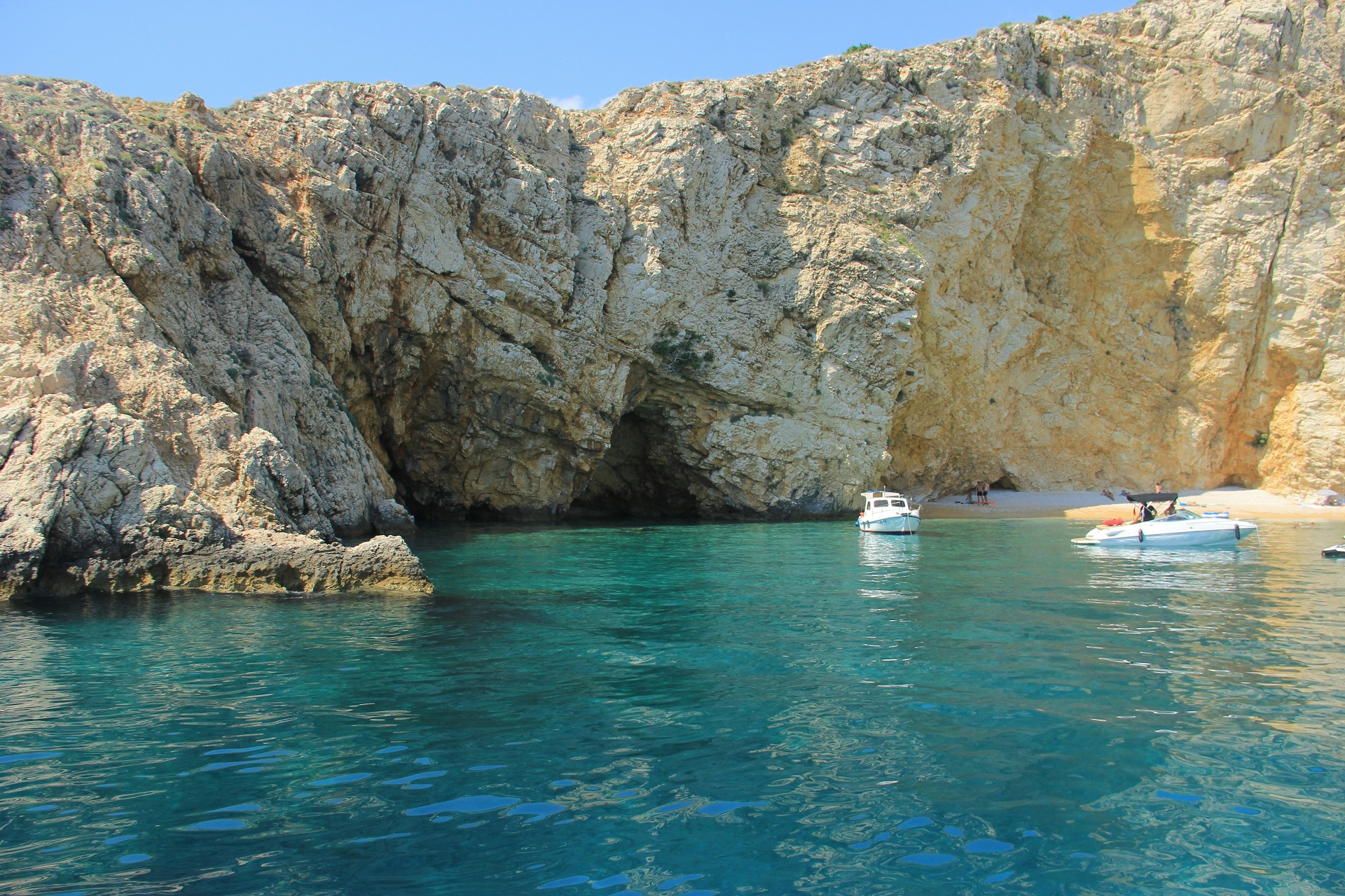
Beyond these main urban harbours, Krk also offers a wide range of natural anchorage opportunities. These are primarily found along the western and southern coastlines, where the geography is more indented and generally better protected from direct exposure to open Kvarner conditions. Bays in these areas are frequently used for daytime anchoring, swimming stops, or relaxed overnight stays when weather conditions allow.
These natural anchorages are typically simple in structure but highly functional. Seabeds vary between sand, rock, and mixed formations depending on location, and water clarity is often good in stable summer conditions. Because of the island’s size, it is usually possible to find alternative anchoring options within a relatively short sailing distance, allowing itineraries to remain flexible even when conditions change unexpectedly.
What makes Krk particularly effective as a sailing destination is the interplay between its formal marina infrastructure and its natural coastal anchoring zones. Structured harbours provide reliability, services, and logistical stability, while open bays offer freedom, flexibility, and quieter environments away from developed waterfronts.
This combination allows sailors to adapt their experience in real time. A route can include well-equipped marina stays in towns like Krk or Punat, followed by informal anchoring stops along more natural stretches of coastline. The transition between these environments is seamless and often achievable within a single sailing day.
Ultimately, the marina and anchorage system around Krk reflects the island’s broader maritime identity: structured yet diverse, developed yet naturally integrated. It supports both carefully planned itineraries and more spontaneous cruising styles, making Krk one of the most adaptable and operationally complete sailing areas in the northern Adriatic.
Swimming and Coastal Experience
Swimming around Krk is highly variable, reflecting the island’s broader geographical complexity and the way its coastline shifts between sheltered bays, open exposures, and transitional inlets. Unlike smaller Adriatic islands where swimming conditions tend to be relatively uniform, Krk offers multiple distinct coastal environments within a single sailing area, each shaping the experience of entering the water in a different way.
On the western side of Krk, swimming is generally more relaxed and accessible. This part of the island is better protected from direct exposure to the open waters of Kvarner Bay, resulting in calmer sea conditions and more stable anchoring opportunities. Bays along this coastline often feature gentle gradients and naturally sheltered positions, allowing boats to anchor comfortably while providing straightforward access to the water.
In these western areas, water clarity is typically good during the summer months, especially in the early morning or late afternoon when wind influence is minimal. The swimming experience here is often characterised by stillness and ease - short distances between boat and shoreline, minimal wave activity, and clear visibility in shallow zones. These conditions make the western coast particularly popular for leisurely swimming stops during multi-day sailing itineraries.
The eastern coastline of Krk offers a noticeably different swimming environment. Here, the island opens directly toward more exposed Kvarner waters, meaning that sea conditions are more dependent on prevailing wind systems and regional weather patterns. When conditions are stable, water clarity can be exceptionally high, with deeper blue tones and strong visibility beneath the surface.
However, this exposure also means that swimming conditions can shift more rapidly. Wind-driven surface movement, particularly during Bura events or stronger Maestral phases, can create more dynamic sea states compared to the western side. As a result, swimming in these areas often feels more open and elemental, closely connected to the broader Adriatic environment rather than sheltered coastal pockets.
This contrast between the two sides of the island is one of the defining features of swimming around Krk. Within a relatively short sailing distance, it is possible to move between calm, protected bays and more open-sea swimming locations. This allows crews to tailor their stops depending on weather, comfort level, and the desired atmosphere of the anchorage.
Across both environments, swimming remains closely integrated into the sailing rhythm. Rather than being limited to designated beaches or structured waterfront areas, it naturally occurs in conjunction with anchoring stops and coastal pauses. Boats position themselves in bays, swimmers enter directly from deck or tender, and the surrounding environment defines the experience rather than built infrastructure.
Ultimately, swimming around Krk reflects the same diversity that defines the island’s sailing conditions. It can be calm and sheltered on one coast, open and dynamic on the other, and consistently shaped by the interplay between wind, geography, and sea state. This variability allows swimming to become an adaptable part of the sailing experience, seamlessly integrated into different parts of an itinerary without relying on formal beach structures or organised coastal zones.
Island Atmosphere and Everyday Life
Unlike more remote Adriatic islands, Krk maintains a strong year-round presence shaped by its direct bridge connection to the mainland near Kraljevica. This physical accessibility fundamentally changes the island’s rhythm of life compared to more isolated destinations in the Kvarner region. Instead of relying primarily on seasonal maritime arrivals, Krk experiences continuous movement of people, goods, and services throughout the year, creating a more stable and sustained pattern of coastal activity.
This constant connectivity influences both population flow and maritime operations. While many smaller islands shift sharply between quiet off-season months and intense summer peaks, Krk maintains a more gradual seasonal transition. Local communities, businesses, and harbour operations remain active beyond the core tourist period, reinforcing the island’s role as both a living settlement and a functional maritime hub within the northern Adriatic system.
The atmosphere of Krk is not uniform but composed of several distinct coastal identities, each contributing a different layer to the island’s overall character. The town of Krk itself presents a compact historic core where stone streets, waterfront promenades, and marina activity coexist in close proximity. Here, the relationship between daily life and the sea is immediate and visible, with fishing boats, sailing yachts, and local traffic sharing the same coastal space.
Further south, Punat represents a more nautical-focused environment. Its identity is strongly shaped by marina infrastructure and long-standing maritime activity, making it one of the most operationally important sailing centres in Kvarner. The rhythm of life here is closely tied to boating cycles, maintenance activity, and seasonal sailing movement, giving it a distinctly maritime-industrial character within a still compact coastal setting.
In contrast, Baška offers a more open and naturally exposed coastal atmosphere. Positioned along a wider bay facing the southern Adriatic, it has a different spatial feel compared to the more sheltered northern and central parts of the island. Here, the coastline opens more broadly toward the sea, creating a stronger sense of horizon and exposure that complements Krk’s otherwise structured coastal identity.
Despite this internal diversity, Krk retains a consistent and deeply rooted maritime identity. Fishing activity remains present across multiple harbours, sailing is a constant feature of coastal movement, and the sea continues to function as a primary axis of connection rather than a peripheral backdrop. The presence of multiple marinas and working harbours reinforces this role, positioning Krk not only as a sailing destination but as an active component of the Adriatic’s nautical infrastructure.
This combination of accessibility, year-round habitation, and maritime function creates an island atmosphere that feels more continuous than seasonal. Life on Krk is not defined solely by summer tourism peaks, but by an ongoing relationship with the sea that persists throughout the year in different forms and intensities.
Ultimately, the everyday rhythm of Krk reflects its unique position within the Adriatic: a large, connected island where local life, sailing activity, and coastal infrastructure coexist in a stable and enduring balance between land and sea.
Connection to Wider Kvarner Sailing Routes
Krk occupies a genuinely central strategic position within northern Adriatic navigation, acting less like an isolated island stop and more like a structural junction within the wider sailing geometry of Kvarner Bay. Its size, orientation, and proximity to both mainland and island systems make it one of the most versatile routing nodes in the region, where multiple sailing directions naturally converge and diverge.
To the north, sailing routes from Krk connect toward mainland Istria and the broader northern Adriatic corridor. This direction typically involves passage through more structured coastal waters, where navigation becomes progressively influenced by mainland geography and coastal urban development. It is also a common direction for itineraries transitioning between Croatian island cruising and more linear coastal sailing toward destinations such as Rijeka and further into the Gulf of Trieste region.
To the south, Krk opens toward Rab and the central island chains of Croatia. This route gradually shifts sailing conditions toward a more open Adriatic character, with increased spacing between islands and a stronger sense of passage navigation rather than coastal proximity. It is a natural continuation for longer itineraries that move from the structured northern Adriatic into the more dispersed island geography of central Dalmatia.
To the east, routes lead into more exposed sectors of Kvarner waters, where wind systems such as the Bura can have a stronger and more immediate impact on sea state. This direction is often used for experienced crews or for crossings that require careful timing and weather awareness. The open-water nature of this zone makes it more dynamic, with fewer sheltered interruptions and a more direct interaction with regional wind patterns.
In contrast, the western side of Krk provides access back into more sheltered coastal channels and island-protected routes. These waters tend to offer smoother sailing conditions, particularly during summer afternoons when the Maestral wind creates consistent but manageable northwesterly airflow. This side of the island is frequently used for more relaxed coastal cruising, short inter-island hops, and itinerary adjustments when offshore conditions become less favourable.
This multi-directional accessibility is what gives Krk its defining role in the Kvarner sailing system. Rather than functioning as a linear waypoint, it operates as a navigational intersection where route decisions can be made dynamically. Sailors can move north, south, east, or west with relatively equal ease, depending on wind conditions, timing, and overall itinerary structure.
As a result, Krk is often used in three distinct ways within sailing plans. It can serve as a base, offering access to multiple surrounding sailing zones from a single stable harbour environment. It can function as a transit island, bridging different regional sailing systems such as northern Adriatic coastal routes and central island cruising grounds. Or it can act as a flexible stopover, inserted into itineraries as a strategic pause point for weather adaptation, provisioning, or route recalibration.
This versatility is particularly valuable in the Kvarner region, where conditions can shift between sheltered and exposed waters within relatively short distances. Having a central island capable of supporting multiple sailing directions reduces planning constraints and increases responsiveness to real-time weather and sea state changes.
Ultimately, the importance of Krk within wider sailing routes lies not only in its size, but in its connectivity. It links different maritime environments together - mainland and islands, sheltered and exposed waters, short coastal passages and longer inter-island crossings - making it one of the most functionally significant navigation points in the northern Adriatic sailing landscape.
Final Thoughts: Why Krk Belongs on an Adriatic Sailing Route
Krk stands out in the Adriatic not through isolation or visual drama, but through scale, connectivity, and functional versatility. As the largest island in the Adriatic, it occupies a structural role within the northern Croatian sailing system that goes beyond scenery or destination appeal. It is an island that actively supports navigation, route planning, and maritime movement across the entire Kvarner Bay region.
For sailors, its value is fundamentally about options. Krk is one of the few islands in the Adriatic where multiple sailing conditions, infrastructure types, and route directions coexist within a single navigable space. Well-developed marinas such as those in Punat and Krk provide reliable harbour access and logistical support, while a wide range of bays and natural anchorages along the western and southern coasts allow for more flexible, weather-dependent stops.
At the same time, the island’s varied coastline introduces significantly different sailing environments within short distances. Sheltered western waters offer calmer cruising conditions, while the eastern side opens toward more exposed Kvarner passages influenced by regional wind systems. This internal diversity means that a single island can accommodate both relaxed coastal sailing and more dynamic open-water navigation without requiring long repositioning.
Adding to this versatility is Krk’s direct connection to the mainland via the bridge near Kraljevica. This feature is rare within the Adriatic island network and gives Krk a logistical advantage that enhances provisioning, accessibility, and overall itinerary flexibility. It allows sailors to integrate island cruising with mainland support more seamlessly than in purely isolated island systems.
Few destinations in the Adriatic offer this level of navigational flexibility within a single geographic unit. Krk functions simultaneously as a sailing base, a transit hub, and a destination in its own right, capable of supporting a wide range of cruising styles and route structures.
In a region defined by contrast - between remote islands, historic coastal towns, and open-sea channels - Krk represents a central point of balance. It is structured yet diverse, accessible yet expansive, and consistently adaptable to changing sailing conditions. This combination makes it one of the most practically valuable and strategically significant stops in any northern Adriatic sailing itinerary, where success is often defined not just by destinations, but by the flexibility to move between them.
Krk Yacht Charter & Sailing Guide
Explore Krk, the largest Adriatic island and a key luxury sailing hub in northern Croatia, offering diverse coastlines, modern marinas, sheltered bays, and direct access to the Kvarner sailing routes.
Send request