Cres

Cres Sailing Guide: A Vast and Untamed Adriatic Island Between Kvarner Channels and Open Sea Horizons
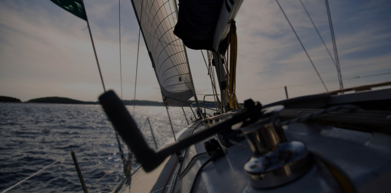
In the northern Adriatic, within the wider Kvarner sailing region, lies Cres - one of the longest and most geographically diverse islands in Croatia. Stretching in a narrow, elongated form through open waters and naturally sheltered channels, Cres creates a sailing environment defined by scale, contrast, and a strong sense of uninterrupted coastal continuity.
Unlike more compact Adriatic islands where sailing identity is concentrated around a single marina town or a tightly defined coastline, Cres unfolds gradually and continuously. Its length transforms navigation into a progressive experience rather than a point-to-point itinerary. Each section of coastline reveals a different character: exposed rocky stretches facing open Kvarner waters, quiet inlets protected by island geometry, and long natural bays where the sea softens into calmer conditions.
For sailors, this means Cres is not experienced in a single arrival moment. Instead, it is discovered through movement - by following its coastline over distance, reading changing wind patterns, and transitioning between environments that shift subtly yet continuously along the route.
One of the most important structural elements shaping sailing in this region is the connection between Cres and its neighbouring island Lošinj. The two islands are linked near Osor, where a narrow channel and bridge create a controlled maritime passage between the northern and southern island systems. This point is not only a geographic connector, but also a navigational threshold where sailing conditions, water movement, and itinerary direction often change noticeably.
This connection allows Cres to function as part of a broader dual-island system. Sailors can move from the more open and exposed northern sections of Kvarner into the increasingly sheltered inner waters around Lošinj, or reverse the direction depending on wind, timing, and route planning. The result is a highly flexible sailing corridor where protected channels and open-sea passages exist in close proximity.
For yacht charter routes, Cres functions simultaneously as a destination and a passage island. Its length gives it presence and variety, while its position within Kvarner Bay makes it a strategic element in northern Adriatic navigation planning. It is large enough to structure multi-day itineraries around its coastline, yet interconnected enough to serve as a transition between different sailing regions.
This dual identity - both expansive and connective - is what defines Cres within the Adriatic sailing landscape. It is not simply an island to stop at, but an island to move through, where geography itself becomes part of the sailing experience.
A Long Island Shaped by Geography and Isolation
The defining characteristic of Cres is its exceptional length and narrow, north-south orientation. This elongated form creates a natural maritime corridor within Kvarner Bay, positioned between the mainland coast of Croatia and the more dispersed island chain that extends toward the central Adriatic. For sailors, this geometry is not just a visual feature but a functional one, directly shaping how routes are planned, how winds are experienced, and how conditions change along relatively short sailing distances.
Because of its structure, Cres behaves less like a single uniform island and more like a sequence of connected coastal environments. Sailing along its perimeter often feels like moving through multiple micro-regions within one continuous landmass. Wind exposure, sea state, and anchoring conditions can shift noticeably depending on whether a vessel is on the eastern or western side of the island, or transitioning between headlands and sheltered inlets.
The eastern coastline of Cres faces more directly toward the open waters of the Velebit Channel and the mainland mountain range. This exposure is particularly significant during the influence of the Bura wind, which can descend rapidly from the mountains and accelerate across the sea surface. In these conditions, the eastern shore experiences stronger gusts, sharper wave formation, and a more dynamic sailing environment overall.
This side of the island is characterised by a more rugged and continuous coastline. Long stretches of rock formations dominate the shore, with fewer deeply indented bays and limited natural protection compared to more enclosed island environments. As a result, sailing here often feels more exposed and direct, with a closer connection to regional weather systems and open-sea dynamics. It is an environment that rewards attention to forecast timing and route flexibility.
In contrast, the western coastline of Cres presents a very different sailing character. Facing inward toward island corridors and partially sheltered waters, this side benefits from reduced wind intensity and more fragmented coastal geometry. The shoreline is more indented, creating a higher frequency of bays, coves, and natural anchoring points that offer protection from prevailing conditions.
These western areas are commonly used for relaxed coastal cruising, especially during summer sailing itineraries. Swimming stops, overnight anchorages, and short inter-island passages are more frequent here, as sea conditions tend to be calmer and more predictable. The transition between open water and sheltered bays is often gradual, allowing sailors to adjust positioning smoothly depending on wind shifts.
The contrast between these two coastal identities is one of the most important features of Cres. Within a single sailing day, it is entirely possible to experience both exposed open-sea navigation along the eastern side and sheltered, island-protected cruising along the western side. This duality gives Cres a rare operational flexibility, particularly valuable in a region where wind systems such as Maestral and Bura can significantly influence sea conditions over short time frames.
Ultimately, the island’s geography creates a natural sailing spectrum: from elemental exposure to protected calm, often within just a few nautical miles. This makes Cres not only a long island in physical terms, but also a layered sailing environment where geography directly defines the rhythm and character of navigation.
Sailing Approach: Long Coastal Entry Through Kvarner Waters
Approaching Cres by yacht typically involves a longer, more atmospheric passage through Kvarner Bay, where open-sea sailing gradually transitions into a layered island environment. Unlike compact Adriatic destinations where harbour entrances become visible early and define the arrival moment, Cres unfolds slowly on the horizon, revealing its scale and structure only as distance closes.
From offshore, the island first appears as a long, low silhouette stretching across the sea line. At this stage, it can be difficult to distinguish individual settlements or coastal features. The impression is one of continuity - an extended landmass rather than a collection of distinct destinations. This is an important psychological aspect of arriving at Cres, as it sets a different expectation compared to more vertically defined or compact islands in the Adriatic.
As vessels approach closer, the coastline begins to resolve into detail. Headlands emerge as subtle breaks in the shoreline, followed by gradual indentations that signal bays and anchorages. Settlements appear one by one rather than as a single dominant focal point, creating a sequential discovery process along the length of the island. This progression turns arrival into a navigational experience rather than a single harbour approach.
Unlike destinations where navigation converges on one primary marina, the entry into Cres is distributed across multiple potential zones. Central and southern sections of the island typically provide the most structured access points, where sheltered waters and marina facilities support easier entry and more immediate shore connection. These areas often serve as natural first contact points for visiting yachts, especially those arriving from longer passages across open Kvarner waters.
However, due to the island’s length and varied coastline, initial arrival rarely defines the end of movement. Many sailors continue to explore further along the coast after their first stop, using Cres as a navigable corridor rather than a fixed destination. This is particularly common in stable summer conditions, when daylight hours and moderate winds allow for extended coastal cruising.
The southern connection toward Lošinj via Osor further enhances this dynamic. Once the channel is reached, the sailing environment shifts again, introducing narrower passages and more sheltered waters that contrast with the earlier open-sea approach. This creates a natural transition between different sailing systems within a single itinerary.
What makes Cres especially distinctive in the Adriatic context is this absence of a single defining arrival moment. Instead, the island presents itself gradually, and even after docking or anchoring, navigation often continues along its coastline. In this sense, arrival is not a conclusion but an entry point into a longer process of coastal exploration.
For yacht charter itineraries, this transforms Cres into more than a stopover. It becomes a navigational landscape - an island experienced through movement, progression, and continuous discovery rather than a single harbour-based destination.
Sailing Conditions Around Cres
The sailing environment around Cres is strongly shaped by its position within Kvarner Bay, one of the most meteorologically active regions of the northern Adriatic. Here, open-sea exposure, mainland mountain influences, and island channel effects combine to create a sailing landscape that is notably more variable than in more sheltered coastal areas further south or along western Istria.
During the summer season, the Maestral is the most consistent wind pattern, typically developing in the early afternoon and arriving from the northwest. Along Cres, this breeze interacts continuously with the island’s extended north-south coastline. On more exposed segments, particularly those facing open Kvarner waters, the Maestral can establish steady and reliable sailing conditions that support comfortable coastal passage-making. In contrast, in bays and more recessed sections of the western coastline, the same wind often weakens or becomes partially disrupted by land formation, creating calmer pockets of water that are well-suited for anchoring or swimming stops.
This variation is one of the defining characteristics of sailing around Cres: conditions are rarely uniform across the island at any given time. Instead, wind strength and sea state shift depending on exposure, orientation, and proximity to surrounding landmasses.
The Bura wind plays an especially important role in shaping the sailing experience in this region. Driven by air descending from the Velebit mountain range on the mainland, Bura events can accelerate through the Kvarner corridor with considerable force. On the eastern coastline of Cres, this can result in significantly stronger gusts, sharper wave formation, and rapidly changing sea conditions over relatively short distances.
When Bura is active, exposed passages along the eastern side require careful route planning and timing. Sea states can build quickly, and visibility or comfort levels may change within a single sailing leg. For this reason, experienced crews often adjust itineraries dynamically, using more sheltered alternatives when necessary.
Despite this exposure, Cres offers a key navigational advantage: protection is always within reach. The western coastline, facing inward toward island channels and partially enclosed waters, typically provides far more stable conditions during wind events. In addition, the passages between Cres and Lošinj offer naturally sheltered routes that can significantly reduce wind impact and sea state intensity.
This proximity between exposed and protected sailing environments is what makes Cres particularly versatile. It allows for real-time adaptation - sailors can move between different wind exposures within relatively short distances, selecting routes based on comfort, safety, or itinerary goals.
Even within a single day of sailing, it is possible to transition from open-water passages influenced by Kvarner conditions to calm, sheltered bays suitable for anchoring. This flexibility is especially valuable in a region where wind systems can shift rapidly and where coastline orientation plays a decisive role in local sailing behaviour.
Ultimately, the sailing conditions around Cres are defined not by uniformity, but by contrast. Exposure and shelter coexist in close proximity, creating an environment where navigation is both dynamic and adaptable. This balance is a key reason why Cres remains one of the most technically interesting and rewarding sailing areas in the northern Adriatic.
Anchorages and Marina Stops
One of the defining strengths of Cres lies in its balanced combination of small-scale marina infrastructure and naturally sheltered anchorages, rather than large, high-density commercial harbour systems. This creates a sailing environment that feels structured where necessary, yet still closely connected to the island’s natural coastline and open-water character.
The town of Cres serves as the primary maritime entry point on the island. Its marina and adjacent waterfront anchorage area provide a practical and accessible stop for visiting yachts arriving from across Kvarner Bay. The harbour is directly integrated into the historic town layout, meaning that stone streets, waterfront promenades, and daily island life begin immediately at the water’s edge. This close spatial relationship between town and sea gives the marina a compact, functional atmosphere rather than an isolated nautical complex.
From a sailing perspective, this makes Cres town a natural starting or transitional point within wider itineraries. It offers essential services, provisioning access, and sheltered berthing, while still maintaining the visual and atmospheric identity of a traditional Adriatic settlement rather than a purely modern marina development.
Beyond the main town, Cres offers a series of smaller anchorages distributed along its coastline, particularly on the western side of the island. These locations are typically less structured, relying on natural bay formations and seabed conditions rather than built infrastructure. In stable summer weather, they are frequently used for daytime anchoring, swimming breaks, or overnight stays during more relaxed cruising segments.
These western anchorages are especially valued for their calmer conditions and proximity to sheltered waters. The coastline here is more indented and generally better protected from direct exposure to the stronger wind systems that can affect the eastern side of the island. As a result, sailors often use this side of Cres to slow down the pace of navigation, transitioning from passage-making to coastal exploration.
Further south, the connection toward Osor becomes one of the most important navigational features in the region. This narrow channel marks the transition between Cres and Lošinj, creating a controlled maritime passage that is both geographically and operationally significant.
The Osor channel is not a conventional anchorage but a dynamic sailing gateway. Its movement is influenced by bridge operation schedules, tidal flow, and local current conditions, all of which can affect timing and passage planning. As vessels pass through this narrow corridor, the sailing environment shifts noticeably - from the more open and linear coastline of Cres into the increasingly sheltered inner waters of the Lošinj archipelago.
This transition is one of the most distinctive experiences in northern Adriatic navigation. It compresses geography into a narrow point where multiple sailing influences converge: wind direction changes, water movement becomes more channelised, and route planning becomes more precise.
Overall, the anchorage and marina system around Cres reflects the island’s broader maritime identity. It is not dominated by large-scale infrastructure, but instead structured through a combination of compact harbour towns, natural bays, and strategic maritime connections. This allows sailors to move fluidly between organised marina stops and open coastal anchoring, adapting their itinerary to both weather conditions and cruising preferences with a high degree of flexibility.
Swimming and Coastal Environment
Swimming around Cres reflects the island’s broader geographical duality, where sheltered western waters and more exposed eastern coastlines create distinctly different marine experiences within a single sailing area. Unlike compact islands with relatively uniform coastal conditions, Cres offers a wide range of swimming environments that shift noticeably depending on orientation, wind exposure, and proximity to open Kvarner waters.
On the western side of Cres, swimming is typically defined by calmer sea states and a more protected maritime setting. Bays along this coastline are partially enclosed by island geometry, which reduces direct exposure to wind-driven waves and creates stable conditions for anchoring. In these areas, water clarity is often high during summer months, particularly in the early morning or late afternoon when surface movement is minimal.
These sheltered western coves are especially suited for sailing itineraries that prioritise relaxed pacing. Boats can anchor comfortably in naturally protected positions, allowing swimmers to enter the water directly from deck or tender. The overall experience here is quiet and controlled, with the coastline providing both physical shelter and a sense of visual enclosure.
In contrast, the eastern coastline of Cres presents a more open and dynamic swimming environment. Facing toward the wider expanse of Kvarner Bay and the mainland Velebit range, this side of the island is more directly influenced by regional wind systems. As a result, sea conditions can vary more significantly, particularly during periods of Bura or stronger Maestral activity.
When conditions are stable, the eastern side often delivers exceptional water clarity, with deeper blue tones and strong underwater visibility. However, the same exposure that enhances clarity can also introduce more surface movement, meaning swimming here is more closely tied to real-time weather and sea state conditions. This creates a more natural, less predictable swimming environment compared to sheltered bays.
The seabed around Cres further enhances this diversity. Along different sections of the coastline, underwater terrain shifts between rocky formations, sandy patches, and mixed seabed structures. Rocky areas often provide clearer water due to reduced sediment disturbance, while sandy zones - particularly in more sheltered bays - create softer gradients and shallower entry points into the sea. Mixed environments offer a combination of both, contributing to varied swimming experiences within short sailing distances.
This diversity allows swimming around Cres to integrate naturally into sailing itineraries rather than being confined to designated beaches or structured coastal zones. Sailors can choose swimming stops based on wind direction, route planning, and desired level of exposure, moving between calm bays and more open-sea locations as conditions evolve.
Ultimately, swimming on Cres is not defined by a single type of coastline experience, but by a continuous spectrum of environments. From quiet, sheltered coves on the western side to more open and elemental conditions along the eastern shore, the island offers a layered coastal setting where the sea is experienced differently from one anchorage to the next, reinforcing Cres’s identity as one of the most geographically varied islands in the northern Adriatic.
Island Atmosphere and Everyday Life
Despite its size, Cres maintains a relatively low-density population and a lifestyle that remains closely tied to traditional island rhythms. Unlike more urbanised Adriatic destinations, where coastal development forms continuous corridors of settlements, Cres is defined by separation and space. Villages and small towns are widely spaced along its long coastline, reinforcing a sense of openness that is immediately noticeable both from land and from the sea.
This spatial distribution shapes the overall atmosphere of the island. Instead of a single dominant centre, life on Cres is organised through a series of smaller coastal communities, each with its own harbour, waterfront identity, and local character. The result is an island that feels fragmented in structure but unified through its maritime connection, where the sea acts as the primary link between settlements rather than roads or dense urban development.
The main pillars of everyday life on Cres remain closely connected to the sea. Fishing continues to play a visible role in coastal towns, not only as a tradition but as a practical part of local economy and daily activity. Small fishing vessels are a regular presence in harbours, particularly in early morning and evening hours, reinforcing the island’s working maritime identity.
Alongside fishing, sailing and seasonal tourism form increasingly important components of the island’s modern economy. During the summer months, coastal towns become more active, with visiting yachts, charter routes, and island-hopping itineraries bringing additional movement into harbours and anchorages. However, even at peak season, Cres does not develop the same level of intensity seen in more densely developed Adriatic destinations.
Outside the main summer period, the island returns to a noticeably quieter rhythm. Many settlements become calm and understated, with reduced visitor presence and a stronger emphasis on local life. This seasonal contrast is present across much of the Adriatic, but on Cres it feels more pronounced due to the island’s size and its naturally dispersed population structure.
The northern and central regions of Cres are particularly striking in this regard. These areas are characterised by long, uninterrupted stretches of coastline where human presence is minimal and development is sparse. Rocky shores, low vegetation, and open views toward the sea dominate the landscape, creating a sense of continuity between natural environment and maritime space.
In these sections of the island, settlements are fewer and further apart, and the coastline often feels more exposed to natural forces than shaped by human intervention. This reinforces the impression that Cres is not an island built around urban expansion, but one shaped primarily by geography - its length, its exposure to wind systems, and its position within the wider Kvarner maritime environment.
Even within inhabited areas, the relationship between land and sea remains central. Harbours are not separate from daily life but integrated into it, with waterfronts functioning as both working spaces and social meeting points. The sea is not a backdrop to island life on Cres; it is its defining structure.
Ultimately, the everyday atmosphere of Cres is shaped by balance - between habitation and openness, tradition and modern sailing activity, and human presence and natural coastline. It is this balance that gives the island its distinctive character: a place where life remains quiet, distributed, and deeply connected to the surrounding Adriatic environment.
Connection to Wider Kvarner Sailing Routes
Cres occupies a central and highly strategic position within the northern Adriatic sailing network, particularly within the broader system of Kvarner Bay. Its elongated north-south orientation places it directly between mainland Croatia and the outer island chain, making it a natural navigational link rather than an isolated cruising destination.
To the south, Cres connects seamlessly with Lošinj through the narrow maritime passage at Osor. This channel represents one of the most distinctive transitions in the Adriatic sailing system. Here, open island coastline gives way to a controlled and highly structured waterway, where navigation is influenced by bridge operations, channel width, and localized currents. The passage effectively merges two islands into a single continuous sailing environment, allowing itineraries to shift smoothly between Cres’s more exposed coastline and Lošinj’s increasingly sheltered waters.
To the north, sailing routes from Cres open back into wider Kvarner waters, where navigation expands toward the mainland coastline and the northern Adriatic corridor. This direction typically involves more open-sea sailing, with longer distances between visual reference points and greater exposure to regional wind systems such as Bura and Maestral. It is a key axis for itineraries moving between central Adriatic islands and northern coastal destinations.
This dual connectivity - south toward island chains and north toward mainland routes - gives Cres a rare level of structural importance within Croatian sailing geography. It is not positioned at the end of a route, but rather along its central flow, where different sailing regions naturally intersect.
Because of this, Cres functions in multiple roles within yacht charter itineraries. It can serve as a standalone cruising destination, offering extended coastline exploration and varied anchorage options. At the same time, it is frequently used as a transitional segment within longer island-hopping routes, particularly those combining exposed Kvarner passages with sheltered channel navigation and calmer inner-island waters.
Its position also enables efficient route flexibility. Sailors can adjust direction based on wind conditions, choosing to move south into the more protected Cres-Lošinj system or north toward more open Kvarner passages depending on weather forecasts and itinerary planning. This adaptability is particularly valuable in a region where wind variability can significantly influence daily sailing decisions.
Ultimately, the importance of Cres within wider sailing routes lies in its connectivity rather than its isolation. It links multiple maritime environments together - open sea and sheltered channels, mainland proximity and island chains, exposed navigation and protected cruising waters - forming one of the key structural corridors in the northern Adriatic sailing system.
Final Thoughts: Why Cres Belongs on an Adriatic Sailing Route
Cres stands out in the Adriatic not through density, spectacle, or concentrated coastal development, but through scale, openness, and navigational diversity. It is an island defined by proportion and geography - long, narrow, and continuously shaped by its exposure to the wider system of Kvarner Bay. For sailors, this creates an experience where distance is not incidental, but central to how the island is understood and navigated.
Unlike compact destinations where arrival is defined by a single harbour or focal point, Cres unfolds gradually. Its coastline reveals itself in segments over time, with each passage introducing a different relationship between sea and land. Headlands, bays, and settlements appear progressively rather than simultaneously, reinforcing the sense that sailing here is a continuous process of discovery rather than a single arrival moment.
For sailors, the real value of Cres lies in its variety. Within one integrated island system, it is possible to experience long coastal passages along exposed eastern shores, sheltered cruising along the western coastline, quiet natural anchorages in remote bays, and structured marina stops in towns such as Cres. This range of conditions is rarely found within a single destination at this scale in the Adriatic.
The island also offers a clear interplay between open and protected sailing environments. Exposed Kvarner waters influence its eastern side, while inner island channels and the connection toward Lošinj through Osor introduce more sheltered and controlled navigation zones. This constant transition between conditions allows itineraries to remain flexible and responsive to wind, sea state, and crew preference.
In a broader Adriatic context defined by contrasts - between compact historic towns, highly developed marina hubs, remote island escapes, and open-sea corridors - Cres represents a more expansive form of sailing. It is not organised around infrastructure density, but around natural scale and geographic continuity. Navigation here is shaped less by harbour proximity and more by coastline length, wind exposure, and the rhythm of passage-making.
This makes Cres one of the most authentic large-island sailing experiences in the northern Adriatic. It does not compress its identity into a single harbour arrival or visual highlight. Instead, it offers a continuous maritime landscape where sailing itself becomes the primary way of experiencing the island.
Ultimately, Cres belongs on an Adriatic sailing route because it expands what sailing means within this region. It introduces space, distance, and variation at a scale that is rare in the northern Adriatic, offering a form of cruising that is structured not by built environment, but by geography itself.
Luxury Yacht Charter Cres - Untamed Adriatic Island Sailing
Discover Cres through premium Adriatic sailing routes defined by secluded anchorages, protected bays, open Kvarner passages, and authentic island atmosphere. From the historic harbour of Cres Town to the sheltered channels near Osor and Lošinj, Cres offers a refined yacht charter experience shaped by nature, distance, and maritime freedom.
Send request